| Cotham | |
|---|---|
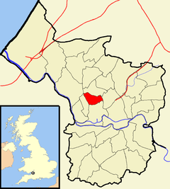
 Boundaries of the city council ward. | |
| Population | 12,554 (2011)[1] |
| OS grid reference | ST583742 |
| Unitary authority | |
| Ceremonial county | |
| Region | |
| Country | England |
| Sovereign state | United Kingdom |
| Post town | BRISTOL |
| Postcode district | BS6 |
| Dialling code | 0117 |
| Police | Avon and Somerset |
| Fire | Avon |
| Ambulance | South Western |
| UK Parliament | |
Cotham /ˈkɒtəm/ is an area of Bristol, England, about 1 mile north of the city centre. It is an affluent, leafy, inner city suburb situated north of the neighbourhoods of Kingsdown and St Paul’s and sandwiched between Gloucester Road (A38) to the east, and Hampton Road to the west.
Cotham is closely related to the neighbourhood of Redland to the north, with the Severn Beach Railway Line broadly marking where Cotham ends and Redland begins, though Ward boundaries show Cotham extending to Redland Road. Redland’s boundaries is usually taken to extend to Coldharbour Road. To the north lies Bishopston and Westbury Park, and Durdham Down to the west. Cotham and Redland together make up the Bristol City Council's Cotham and Redland Conservation Area.[2]
It is also the name of a council ward of the city, which also includes other areas.
- ^ "Cotham" (PDF). 2011 Census Ward Information Sheet. Archived from the original (PDF) on 4 March 2016. Retrieved 26 February 2015.
- ^ Bristol City Council (September 2011). "Cotham & Redland Character Appraisal & Management Proposals". Archived from the original on 4 March 2016. Retrieved 18 August 2018.
© MMXXIII Rich X Search. We shall prevail. All rights reserved. Rich X Search
