Back مقاطعات أيرلندا الشمالية Arabic Графствы Паўночнай Ірландыі Byelorussian Κομητείες της Βόρειας Ιρλανδίας Greek Luettelo Pohjois-Irlannin historiallisista kreivikunnista Finnish מחוזות צפון אירלנד HE Contee dell'Irlanda del Nord Italian 北アイルランドのカウンティ Japanese 북아일랜드의 주 Korean Graafschappen van Noord-Ierland Dutch Hrabstwa Irlandii Północnej Polish
| Counties of Northern Ireland | |
|---|---|
 | |
| Category | Former local government |
| Location | Northern Ireland |
| Number | Six |
| Populations | 63,585 (Fermanagh) 651,321 (Antrim) |
| Areas | 512 sq mi (1,330 km2) (Armagh) 1,261 sq mi (3,270 km2) (Tyrone) |
| Government |
|
| Subdivisions |
|
| This article is part of a series within the Politics of the United Kingdom on the |
 |
|---|
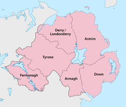
Northern Ireland is divided into six counties, namely: Antrim, Armagh, Down, Fermanagh, Londonderry[n 1] and Tyrone. Six largely rural administrative counties based on these were among the eight primary local government areas of Northern Ireland from its 1921 creation until 1973.[1] The other two local government areas were the urban county boroughs of Derry[n 1] (geographically part of the County of Londonderry) and Belfast (geographically split between the counties of Antrim and Down).
The six counties date from the Kingdom of Ireland; five were created between 1570 and 1591 in the Tudor conquest of Ireland, while county Londonderry dates from 1613 and the Plantation of Ulster.[2] The total number of counties in the island of Ireland is 32, with Northern Ireland and the Republic of Ireland often respectively called "the Six Counties" and "the Twenty-Six Counties", especially by Irish nationalists opposed to the partition of Ireland. The 1898–1973 administrative counties were subdivided into county districts. The two-tier county/district system was replaced with a single-tier of "districts", numbering 26 in 1973 and rationalised into 11 in 2015. The areas corresponding to the six counties and two county boroughs remain in use for some administrative purposes, and the six historic counties retain a popular identity.
Cite error: There are <ref group=n> tags on this page, but the references will not show without a {{reflist|group=n}} template (see the help page).
© MMXXIII Rich X Search. We shall prevail. All rights reserved. Rich X Search