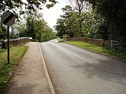
Cropredy Bridge | |
|---|---|
 View across the bridge towards Williamscot | |
| Coordinates | 52°06′53″N 1°18′54″W / 52.1147°N 1.3150°W |
| Carried | minor road |
| Crossed | River Cherwell |
| Locale | between Cropredy and Williamscot, Oxfordshire |
| Owner | Oxfordshire County Council |
| Maintained by | Oxfordshire County Council |
| Website | web |
| Characteristics | |
| Material | Concrete |
| No. of spans | 3 |
| History | |
| Construction end | 1937 |
| Opened | 1937 |
| Collapsed | 1644 (Site of the Battle of Cropredy Bridge) |
| Replaced | Medieval bridge repaired in 1691 |
| Location | |
 | |
Cropredy Bridge is a bridge in north Oxfordshire, England, that carries the minor road between Cropredy and the hamlet of Williamscot. It spans the River Cherwell, which is also the boundary between the civil parishes of Wardington (which includes Williamscot) and Cropredy. The bridge has three spans, a reinforced concrete deck and is faced with Hornton stone.[1][2] Each of the three spans is 12 feet (3.7 m).[1] The present bridge was completed in 1937, but there has been a bridge on this site since at least 1312.[2][3]
- ^ a b Toynbee & Leeming 1938, p. 127.
- ^ a b Crossley 1972, pp. 157–175.
- ^ Toynbee & Leeming 1938, p. 123.
© MMXXIII Rich X Search. We shall prevail. All rights reserved. Rich X Search
