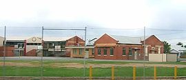
| Croydon Park Adelaide, South Australia | |||||||||||||||
|---|---|---|---|---|---|---|---|---|---|---|---|---|---|---|---|
 St Margaret Mary's Primary School on Torrens Road | |||||||||||||||
| Population | 4,230 (SAL 2021)[1] | ||||||||||||||
| Postcode(s) | 5008 | ||||||||||||||
| LGA(s) | City of Port Adelaide Enfield | ||||||||||||||
| State electorate(s) | Croydon | ||||||||||||||
| Federal division(s) | Adelaide | ||||||||||||||
| |||||||||||||||
Croydon Park is a north-western suburb of Adelaide 5.9 km from the CBD, in the state of South Australia, Australia and is within the City of Port Adelaide Enfield. It is adjacent to Dudley Park, Devon Park, Renown Park, Regency Park, Ferryden Park Kilkenny, and West Croydon. The post code for Croydon Park is 5008. It is bounded to the south by Lamont Street and Torrens Road, to the north by Regency Road and in the east and west by Harrison Road and Goodall Avenue respectively. Croydon Park is predominantly a residential suburb, with a warehousing presence on the northern edges near Regency Road.[2] Croydon Park has been completely divided by the North-South Motorway.
- ^ Australian Bureau of Statistics (28 June 2022). "Croydon Park (SA) (suburb and locality)". Australian Census 2021 QuickStats. Retrieved 28 June 2022.
- ^ Adelaide and surrounds street directory (49th ed.). UBD. 2011. ISBN 978-0-7319-2652-7.
© MMXXIII Rich X Search. We shall prevail. All rights reserved. Rich X Search
