Back تلال السرو ARZ Cypress Hills (mga bungtod sa Alberta) CEB Cypress Hills German Montañas Cypress Spanish Montagne de Cyprès French Cypress Hills Italian Cypress Hills (Canada) LLD Cypress Hills (Canada) Dutch
| Cypress Hills | |
|---|---|
 The Cypress Hills | |
| Highest point | |
| Elevation | 1,468 m (4,816 ft) |
| Coordinates | 49°37′48″N 110°21′34″W / 49.63000°N 110.35944°W |
| Dimensions | |
| Area | 2,500 km2 (970 sq mi) |
| Geography | |
| Country | Canada |
| Provinces | Alberta and Saskatchewan |
| Topo map | NTS 72E9 Elkwater Lake |
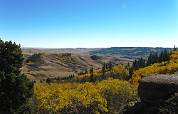
The Cypress Hills are a geographical region of hills in southwestern Saskatchewan and southeastern Alberta, Canada. The hills are part of the Missouri Coteau upland. The hills cover an area of approximately 2,500 km2 (970 sq mi).[1] About 400 km2 (150 sq mi) or 16% of this area is an interprovincial park.
The highest point in the Cypress Hills is at Head of the Mountain in Alberta at 1,466 m (4,810 ft). The highest point in Saskatchewan is 1,392 m (4,567 ft), in a farmer's field in the Cypress Hills, at 49°33′N 109°59′W / 49.550°N 109.983°W.[2][3]
- ^ "Cypress Hills". www.thecanadianencyclopedia.ca.
- ^ Cite error: The named reference
statscanwas invoked but never defined (see the help page). - ^ Kerslake, Danny (5 July 2017). "Mystery of Sask.'s nameless highest point solved by podcast". CBC News. Retrieved 5 March 2018.
© MMXXIII Rich X Search. We shall prevail. All rights reserved. Rich X Search
