Back مقاطعة دالاس (أركنساس) Arabic Dallas County, Arkansas BAR Далас (окръг, Арканзас) Bulgarian ডাল্লাস কাউন্টি, আরকান্সাস BPY Dallas Gông (Arkansas) CDO Даллас (гуо, Арканзас) CE Dallas County (kondado sa Tinipong Bansa, Arkansas) CEB Dallas County, Arkansas Welsh Dallas County (Arkansas) German Κομητεία Ντάλας (Άρκανσο) Greek
Dallas County | |
|---|---|
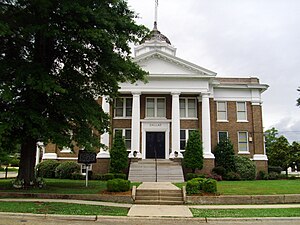
 Courthouse in Fordyce | |
 Location within the U.S. state of Arkansas | |
 Arkansas's location within the U.S. | |
| Coordinates: 33°58′37″N 92°40′23″W / 33.976944444444°N 92.673055555556°W | |
| Country | |
| State | |
| Founded | January 1, 1845 |
| Named for | George M. Dallas |
| Seat | Fordyce |
| Largest city | Fordyce |
| Area | |
| • Total | 668 sq mi (1,730 km2) |
| • Land | 667 sq mi (1,730 km2) |
| • Water | 0.7 sq mi (2 km2) 0.1% |
| Population (2020) | |
| • Total | 6,482 |
| • Density | 9.7/sq mi (3.7/km2) |
| Time zone | UTC−6 (Central) |
| • Summer (DST) | UTC−5 (CDT) |
| Congressional district | 4th |
Dallas County is a county located in the U.S. state of Arkansas. As of the 2020 census, the population was 6,482,[1] making it the fourth-least populous county in Arkansas. The county seat is Fordyce.[2] Dallas County is Arkansas's 49th county, formed on January 1, 1845; it was named for George M. Dallas, 11th Vice President of the United States.
- ^ "Census - Geography Profile: Dallas County, Arkansas". United States Census Bureau. Retrieved January 19, 2023.
- ^ "Find a County". National Association of Counties. Archived from the original on May 31, 2011. Retrieved June 7, 2011.
© MMXXIII Rich X Search. We shall prevail. All rights reserved. Rich X Search