Back دانا (إنديانا) Arabic دانا ARZ دانا، ایندیانا AZB Dana (Indiana) Catalan Дейна (Индиана) CE Dana (lungsod sa Tinipong Bansa, Indiana) CEB Dana (Indiana) German Dana (Indiana) Spanish Dana (Indiana) Basque دانا، ایندیانا Persian
Dana, Indiana | |
|---|---|
 Maple Street (SR 71) | |
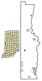
 Location of Dana in Vermillion County, Indiana. | |
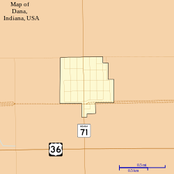
 Map of Dana | |
| Coordinates: 39°48′24″N 87°29′39″W / 39.80667°N 87.49417°W | |
| Country | United States |
| State | Indiana |
| County | Vermillion |
| Township | Helt |
| Established | 1874 |
| Area | |
| • Total | 0.29 sq mi (0.76 km2) |
| • Land | 0.29 sq mi (0.76 km2) |
| • Water | 0.00 sq mi (0.00 km2) |
| Elevation | 640 ft (195 m) |
| Population (2020) | |
| • Total | 555 |
| • Density | 1,900.68/sq mi (733.89/km2) |
| Time zone | UTC-5 (EST) |
| • Summer (DST) | UTC-5 (EST) |
| ZIP code | 47847 |
| Area code | 765 |
| FIPS code | 18-16732[3] |
| GNIS feature ID | 433305 |
Dana is a town in Helt Township, Vermillion County, Indiana, United States.[4] The population was 555 at the 2020 census. It is primarily a farming community.
- ^ "2020 U.S. Gazetteer Files". United States Census Bureau. Retrieved March 16, 2022.
- ^ "US Board on Geographic Names". United States Geological Survey. October 25, 2007. Retrieved January 31, 2008.
- ^ "U.S. Census website". United States Census Bureau. Retrieved January 31, 2008.
- ^ "Dana, Indiana". Geographic Names Information System. United States Geological Survey, United States Department of the Interior. Retrieved July 15, 2016.
© MMXXIII Rich X Search. We shall prevail. All rights reserved. Rich X Search