Back إقليم أياكوتشو Arabic Ayaquchu jach'a suyu Aymara Аякуча (рэгіён) Byelorussian Аякуча (дэпартамэнт) BE-X-OLD Аякучо (регион) Bulgarian Regió d'Ayacucho Catalan Ayacucho (rehiyon) CEB Ayacucho (region) Danish Region Ayacucho German Departemento Ajakuĉo Esperanto
Ayacucho
| |
|---|---|
 Sara Sara and Lake Parinacochas in front of it | |
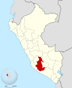
 Location of the Department of Ayacucho in Peru | |
| Country | Peru |
| Subdivisions | 11 provinces and 111 districts |
| Largest city | Ayacucho |
| Capital | Ayacucho |
| Government | |
| • Governor | Wilfredo Oscorima Núñez (2023–2026) |
| Area | |
| • Total | 43,814.8 km2 (16,917.0 sq mi) |
| Elevation (Capital) | 2,746 m (9,009 ft) |
| Highest elevation | 5,505 m (18,061 ft) |
| Lowest elevation | 1,800 m (5,900 ft) |
| Population (2017) | |
| • Total | 616,176 |
| • Density | 14/km2 (36/sq mi) |
| UBIGEO | 05 |
| Dialing code | 066 |
| ISO 3166 code | PE-AYA |
| Principal resources | Potatoes, wheat, olluco, barley, sheep and handicrafts. |
| Poverty rate | 72.5% |
| Percentage of Peru's GDP | 0.65% |
| Website | www.regionayacucho.gob.pe |
Ayacucho (Spanish pronunciation: [aʝaˈkutʃo] ), known as Huamanga from its creation in 1822 until 1825,[1][2] is a department and region of Peru, located in the south-central Andes of the country. Its capital is the city of Ayacucho. The region was one of the hardest hit in the 1980s during the guerrilla war waged by Shining Path known as the internal conflict in Peru.
A referendum was held on 30 October 2005, in order to decide whether the department would merge with the departments of Ica and Huancavelica to form the new Ica-Ayacucho-Huancavelica Region, as part of the decentralization process in Peru. The proposal failed and no merger was carried out.[citation needed]
© MMXXIII Rich X Search. We shall prevail. All rights reserved. Rich X Search

