Back إقليم بونو Arabic Punu jach'a suyu Aymara Пуна (рэгіён) Byelorussian Пуна (дэпартамэнт) BE-X-OLD Пуно (регион) Bulgarian Regió de Puno Catalan Puno (rehiyon) CEB Puno (region) Danish Region Puno German Departemento de Puno (Peruo) Esperanto
Puno
| |
|---|---|
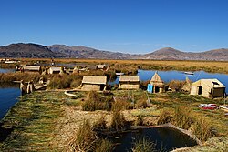
 Uru people next to Lake titicaca | |
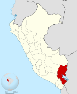
 Location of the Puno Region in Peru | |
| Coordinates: 15°04′S 70°07′W / 15.07°S 70.12°W | |
| Country | Peru |
| Subdivisions | 13 provinces and 108 districts |
| Capital | Puno |
| Government | |
| • Governor | Richard Hancco (2023-present) |
| Area | |
| • Total | 66,997 km2 (25,868 sq mi) |
| Population (2017) | |
| • Total | 1,172,697 |
| • Density | 18/km2 (45/sq mi) |
| UBIGEO | 21 |
| Dialing code | 0+51 |
| ISO 3166 code | PE-PUN |
| Principal resources | Quinoa; it is also the nation's largest producer of potatoes, sheep, alpacas and llamas. |
| Poverty rate | 60.8% (INEI 2009) |
| Percentage of Peru's GDP | 2.3% |
| Website | www.regionpuno.gob.pe |
Puno (Spanish pronunciation: [ˈpuno]) is a department and region in southeastern Peru. It is the fifth largest department in Peru, after Cuzco, Madre de Dios, Ucayali, and Loreto. It is bordered by Bolivia on the east, the departments of Madre de Dios on the north, Cusco and Arequipa on the west, Moquegua on the southwest, and Tacna on the south. Its capital is the city of Puno, which is located on Lake Titicaca in the geographical region known as the Altiplano or high sierra.
Puno was the territory of the Tiahuanacos (800 A.D. – 1200 A.D.), who were the highest cultural expression of the Aymara people who established themselves in what is today Peru and Bolivia. The Incas took over these lands in the fifteenth century, and the Spanish, attracted by the mining industry developed there, left an important Colonial legacy throughout the entire area.
© MMXXIII Rich X Search. We shall prevail. All rights reserved. Rich X Search

