Back ধর্মাপুরি BPY Dharmapuri (lungsod) CEB Dharmapuri German Dharmapuri DIQ Dharmapuri Spanish دارماپوری Persian Dharmapuri French धर्मपुरी Hindi Dharmapuri Italian ダルマプリ Japanese
This article includes a list of general references, but it lacks sufficient corresponding inline citations. (September 2023) |
Dharmapuri
Thagadur | |
|---|---|
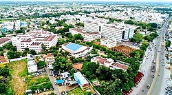
 Aerial view of mid-city | |
| Nickname(s): Thagadoor, Dharmapuri | |
| Coordinates: 12°07′16″N 78°09′30″E / 12.121100°N 78.158200°E | |
| Country | |
| State | |
| District | Dharmapuri |
| Established | 10th Century BC |
| Founded by | The King Adhiyaman |
| Government | |
| • Type | Special Grade Municipality |
| • Body | Dharmapuri Municipality |
| Area | |
| • Total | 25.32 km2 (9.78 sq mi) |
| • Rank | 9 |
| Elevation | 482 m (1,581 ft) |
| Population (2017) | |
| • Total | 113,218 |
| • Density | 4,500/km2 (12,000/sq mi) |
| Languages | |
| • Official | Tamil |
| Time zone | UTC+5:30 (IST) |
| PIN | 636(7xx),636(8xx) |
| Telephone code | 4342 |
| Vehicle registration | TN-29 |
| Website | www.dharmapuri.nic.in |
Dharmapuri is a city in the north western part of Tamil Nadu, India. It serves as the administrative headquarters of Dharmapuri district which is the first district created in Tamil Nadu after the independence of India by splitting it from then Salem district on 2 October 1965. The city is located 50 km from Krishnagiri, 69 km from Salem, 60 km from Tirupattur, 90 km from Hosur, 117 km from Thiruvannamalai, 126 km from Bangalore and Erode, 181 km from Tiruppur, 200 km from Coimbatore and Tiruchirappalli, 300 km from Madurai and the state capital Chennai. It is located between latitudes N 11 47’ and 12 33’ and longitudes E 77 02’ and 78 40’. It is one of the major leading cultivators and producers of mangoes in the state along with Krishnagiri, and is often referred as Mango Capital of India.
© MMXXIII Rich X Search. We shall prevail. All rights reserved. Rich X Search

