Back Doneraile CEB Doneraile German Doneraile Spanish Doneraile Basque Dún ar Aill Irish Донерейл Russian Doneraile Swedish
Doneraile
Dún ar Aill | |
|---|---|
Town | |
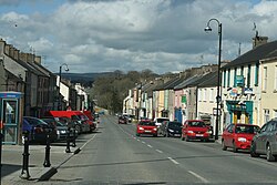
 Doneraile's main street | |
| Coordinates: 52°13′02″N 8°35′05″W / 52.2172°N 8.5847°W | |
| Country | Ireland |
| Province | Munster |
| County | County Cork |
| Elevation | 269 ft (82 m) |
| Population | 857 |
| Time zone | UTC+0 (WET) |
| • Summer (DST) | UTC-1 (IST (WEST)) |
| Irish Grid Reference | R601074 |
| Year | Pop. | ±% |
|---|---|---|
| 1821 | 2,456 | — |
| 1831 | 2,652 | +8.0% |
| 1841 | 2,722 | +2.6% |
| 1851 | 1,856 | −31.8% |
| 1861 | 1,475 | −20.5% |
| 1871 | 1,314 | −10.9% |
| 1881 | 1,208 | −8.1% |
| 1891 | 833 | −31.0% |
| 1901 | 797 | −4.3% |
| 1911 | 829 | +4.0% |
| 1926 | 809 | −2.4% |
| 1936 | 740 | −8.5% |
| 1946 | 801 | +8.2% |
| 1951 | 775 | −3.2% |
| 1956 | 745 | −3.9% |
| 1961 | 725 | −2.7% |
| 1966 | 710 | −2.1% |
| 1971 | 799 | +12.5% |
| 1981 | 920 | +15.1% |
| 1986 | 846 | −8.0% |
| 1991 | 815 | −3.7% |
| 1996 | 761 | −6.6% |
| 2002 | 800 | +5.1% |
| 2006 | 759 | −5.1% |
| [2][3][4][5][6] | ||
Doneraile (Irish: Dún ar Aill, meaning 'fort of the cliff'),[7] historically Dunnerail, is a town in County Cork, Ireland. It is on the R581 regional road 8 km (5.0 mi) east of the N20 road, which runs from Limerick to Cork. It is about 12 km (7.5 mi) north of Mallow town. It is on the River Awbeg, a branch of the Blackwater. Doneraile is part of the Cork East Dáil constituency.
- ^ "Census Mapping - Towns: Doneraile - Population Snapshot". visual.cso.ie. Central Statistics Office. Retrieved 16 June 2024.
- ^ "Census for post 1821 figures". Archived from the original on 20 September 2010. Retrieved 1 August 2009.
- ^ "histpop.org". Archived from the original on 7 May 2016.
- ^ "Northern Ireland Census of Population". Archived from the original on 17 February 2012. Retrieved 24 December 2015.
- ^ Lee, JJ (1981). "On the accuracy of the Pre-famine Irish censuses". In Goldstrom, J. M.; Clarkson, L. A. (eds.). Irish Population, Economy, and Society: Essays in Honour of the Late K. H. Connell. Oxford, England: Clarendon Press.
- ^ Mokyr, Joel; O Grada, Cormac (November 1984). "New Developments in Irish Population History, 1700-1850". The Economic History Review. 37 (4): 473–488. doi:10.1111/j.1468-0289.1984.tb00344.x. hdl:10197/1406. Archived from the original on 4 December 2012.
- ^ "Dún ar Aill / Doneraile (see archival records)". logainm.ie. Placenames Database of Ireland. Retrieved 30 December 2021.
© MMXXIII Rich X Search. We shall prevail. All rights reserved. Rich X Search
