Back Droylsden CEB Droylsden Welsh Droylsden German Droylsden Spanish Droylsden Basque درویلزدن Persian Droylsden Irish Droylsden Italian Droylsden LLD Droylsden Dutch
| Droylsden | |
|---|---|
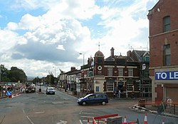
 Droylsden town centre | |
Location within Greater Manchester | |
| Population | 22,689 (2011 Census) |
| OS grid reference | SJ8998 |
| • London | 161 miles (259 km) SSE |
| Metropolitan borough | |
| Metropolitan county | |
| Region | |
| Country | England |
| Sovereign state | United Kingdom |
| Post town | MANCHESTER |
| Postcode district | M43 |
| Dialling code | 0161 |
| Police | Greater Manchester |
| Fire | Greater Manchester |
| Ambulance | North West |
| UK Parliament | |
Droylsden is a town in Tameside, Greater Manchester, England, 4 miles (6.4 km) east of Manchester and 2 miles (3.2 km) west of Ashton-under-Lyne, with a population at the 2011 Census of 22,689.[1]
Within the boundaries of the historic county of Lancashire, in the mid-19th century Droylsden grew as a mill town on the Ashton canal. Beginning in the early 1930s, Droylsden's population expanded rapidly as it became a housing overflow area for neighbouring Manchester.
Since 1785, the Fairfield area of Droylsden has been home to a Moravian Church.[2]
- ^ "2011 census for Droylsden". Archived from the original on 4 February 2015. Retrieved 4 February 2015.
- ^ "Moravian Atlas UK Congregation Locations 2003". Moravian Church in the British Province. Archived from the original on 17 June 2007. Retrieved 16 May 2007.
© MMXXIII Rich X Search. We shall prevail. All rights reserved. Rich X Search
