Back Duitama AVK Duitama (munisipyo) CEB Duitama German Ντουιτάμα Greek Duitama Spanish دویتاما Persian Duitama French Duitama Galician דואיטמה HE Duitama Italian
Duitama | |
|---|---|
Municipality and city | |
Top: Pueblito Boyacense, Second: Duitama rural area, Third: Briceño-Tunja-Sogamoso Highway, Four: Skyline Duitama Bottom: Antonio Nariño University - Duitama Campus | |
| Nickname(s): Perla de Boyacá ("Pearl of Boyacá") | |
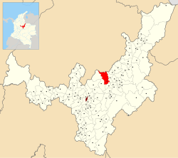
 Location of the town and municipality of Duitama in Boyacá Department | |
| Coordinates: 5°50′N 73°01′W / 5.833°N 73.017°W | |
| Country | |
| Department | Boyacá |
| Province | Tundama Province |
| Founded | Pre-Conquest |
| Erected | July 27, 1819 |
| Government | |
| • Type | Municipality |
| • Mayor | Constanza Ramírez Acevedo (2020–2023) |
| Area | |
| • Municipality and city | 266.93 km2 (103.06 sq mi) |
| • Urban | 12.7 km2 (4.9 sq mi) |
| Elevation | 2,590 m (8,500 ft) |
| Population (2023 est.) | |
| • Municipality and city | 131,591 |
| • Density | 490/km2 (1,300/sq mi) |
| • Urban | 114,192 |
| • Urban density | 9,000/km2 (23,000/sq mi) |
| Demonym | Duitamense |
| Postal code | 150461-69 |
| Area code | +7 |
| Website | Official website |
Preview warning: Page using Template:Infobox settlement with unknown parameter "map_size"
 |
| Part of a series on |
| Muisca culture |
|---|
| Topics |
| Geography |
| The Salt People |
| Main neighbours |
| History and timeline |

Duitama (Spanish pronunciation: [dwiˈtama]) is a city and municipality in the department of Boyacá. It's the capital of the Tundama Province. Duitama is located 195 kilometres (121 mi) northeast of Bogotá, the capital of Colombia and 50 kilometres (31 mi) northeast of Tunja, the capital of Boyacá.[1] In 2023 Duitama had an estimated population of 131,591.[2]
- ^ (in Spanish) Official website Duitama
- ^ Telefónicas, Telencuestas-Encuestas. "Cuántos habitantes tiene Duitama, Boyacá en 2023". Telencuestas (in Spanish). Retrieved 2023-09-28.
© MMXXIII Rich X Search. We shall prevail. All rights reserved. Rich X Search


