| East Victoria Park Perth, Western Australia | |||||||||||||||
|---|---|---|---|---|---|---|---|---|---|---|---|---|---|---|---|
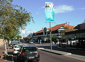
 Albany Highway running through the centre of East Victoria Park | |||||||||||||||
 | |||||||||||||||
| Coordinates | 31°59′17″S 115°54′14″E / 31.988°S 115.904°E | ||||||||||||||
| Population | 10,569 (SAL 2021)[1] | ||||||||||||||
| Established | 1890s | ||||||||||||||
| Postcode(s) | 6101 | ||||||||||||||
| Area | 4 km2 (1.5 sq mi) | ||||||||||||||
| Location | 6 km (4 mi) from Perth | ||||||||||||||
| LGA(s) | Town of Victoria Park | ||||||||||||||
| State electorate(s) | Victoria Park and South Perth | ||||||||||||||
| Federal division(s) | Swan | ||||||||||||||
| |||||||||||||||
East Victoria Park (nicknamed East Vic Park) is an inner south-eastern suburb of Perth, Western Australia, located within the Town of Victoria Park.
East Victoria Park is located south-east of the suburb of Victoria Park, approximately 5 kilometres (3.1 mi) from the Perth central business district. It is primarily residential but includes a continuation of the Albany Highway commercial strip. It is bounded by the Armadale-Thornlie railway line to the north-east and shares Carlisle and Oats Street railway stations with the neighbouring suburb of Carlisle.
- ^ Australian Bureau of Statistics (28 June 2022). "East Victoria Park (suburb and locality)". Australian Census 2021 QuickStats. Retrieved 28 June 2022.
© MMXXIII Rich X Search. We shall prevail. All rights reserved. Rich X Search
