Back ادوينستوى ARZ Edwinstowe BAR Edwinstowe Catalan Edwinstowe (lungsod) CEB Edwinstowe Welsh Edwinstowe German Edwinstowe Spanish ادوینزتو Persian Edwinstowe French Edwinstowe Dutch
| Edwinstowe | |
|---|---|
| Village and civil parish | |
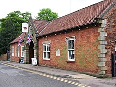
 Sherwood Forest Art & Craft Centre, Forest Corner (off the B6034 Swinecote Road, Edwinstowe towards Budby road). They were originally stables for Edwinstowe Hall, then used as laboratories for the coal mining industry. | |
 Parish map | |
Location within Nottinghamshire | |
| Area | 6.8 sq mi (18 km2) |
| Population | 5,320 (2021) |
| • Density | 782/sq mi (302/km2) |
| OS grid reference | SK 6266 |
| • London | 120 mi (190 km) SSE |
| District | |
| Shire county | |
| Region | |
| Country | England |
| Sovereign state | United Kingdom |
| Post town | MANSFIELD |
| Postcode district | NG21 |
| Dialling code | 01623 |
| Police | Nottinghamshire |
| Fire | Nottinghamshire |
| Ambulance | East Midlands |
| UK Parliament | |
| Website | www |
Edwinstowe is a village and civil parish in the Newark and Sherwood district of Nottinghamshire, England, on the edge of Sherwood Forest and the Dukeries. It is associated with the legends of Robin Hood and Maid Marian, and to a lesser extent Edwin of Northumbria, from where the village gets its name. The civil parish population at the 2011 census was 5,188.[1] A 2019 estimate put it at 5,261,[2][3] and was 5,320 at the 2021 census.[4]
- ^ "Civil Parish population 2011". Neighbourhood Statistics. Office for National Statistice. Retrieved 8 April 2016.
- ^ City Population. Retrieved 9 December 2020.
- ^ Joseph Rodgers, The Scenery of Sherwood Forest with an Account of some Eminent People there, (1908) retrieved on 9 April 2023
- ^ UK Census (2021). "2021 Census Area Profile – Edwinstowe parish (E04007898)". Nomis. Office for National Statistics. Retrieved 1 February 2024.
© MMXXIII Rich X Search. We shall prevail. All rights reserved. Rich X Search
