| Thuringowa Queensland—Legislative Assembly | |||||||||||||||
|---|---|---|---|---|---|---|---|---|---|---|---|---|---|---|---|
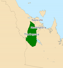
 Electoral map of Thuringowa, 2024 | |||||||||||||||
| State | Queensland | ||||||||||||||
| MP | Aaron Harper | ||||||||||||||
| Party | Labor | ||||||||||||||
| Namesake | City of Thuringowa | ||||||||||||||
| Electors | 36,034 (2020) | ||||||||||||||
| Area | 261 km2 (100.8 sq mi) | ||||||||||||||
| Demographic | Provincial | ||||||||||||||
| Coordinates | 19°22′S 146°39′E / 19.367°S 146.650°E | ||||||||||||||
| |||||||||||||||

Thuringowa is an electorate in the Legislative Assembly of the state of Queensland, Australia.
The division encompasses suburbs of the former City of Thuringowa on the western edge of Townsville in North Queensland, stretching from Deeragun in the north to Kelso in the south. It includes the suburbs of Bushland Beach, Shaw, Thuringowa Central, Rasmussen, Condon and Kirwan.[1][2]
The Electorate is bordered by the Hinchinbrook (North and West), Burdekin (South), Mundingburra and Townsville (both East) Electorates.[3]
- ^ "ABC Electorate guide". Australian Broadcasting Corporation. Archived from the original on 13 December 2007. Retrieved 14 December 2006.
- ^ "Team Beattie Electorate guide". Archived from the original on 29 August 2007. Retrieved 21 December 2006.
- ^ "Electoral Commission of Queensland map of Electorate" (PDF). Archived from the original (PDF) on 17 September 2006. Retrieved 15 December 2006.
© MMXXIII Rich X Search. We shall prevail. All rights reserved. Rich X Search
