| Elephant Rocks State Park | |
|---|---|
 | |
| Location | Iron County, Missouri, United States |
| Coordinates | 37°39′16″N 90°41′17″W / 37.65444°N 90.68806°W[1] |
| Area | 133.75 acres (54.13 ha)[2] |
| Elevation | 1,273 ft (388 m)[1] |
| Established | 1967[3] |
| Visitors | 106,869 (in 2022)[4] |
| Governing body | Missouri Department of Natural Resources |
| Website | Elephant Rocks State Park |
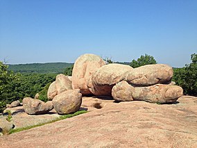
Elephant Rocks State Park is a state-owned geologic reserve and public recreation area encompassing an outcropping of Precambrian granite in the Saint Francois Mountains in the U.S. state of Missouri. The state park is named for a string of large granite boulders which resemble a train of pink circus elephants.[5] The park was created following the donation of the land to the state in 1967 by geologist Dr. John Stafford Brown.[6] The park is used for picnicking, rock climbing, and trail exploration. It is managed by the Missouri Department of Natural Resources.[5]
- ^ a b "Elephant Rocks State Park". Geographic Names Information System. United States Geological Survey, United States Department of the Interior.
- ^ Cite error: The named reference
parkdatawas invoked but never defined (see the help page). - ^ Cite error: The named reference
acquisitionwas invoked but never defined (see the help page). - ^ "Missouri State Park Attendance For January - December, 2022" (PDF). Missouri State Parks. February 3, 2023.
- ^ a b Cite error: The named reference
parkswas invoked but never defined (see the help page). - ^ Cite error: The named reference
naturalareaswas invoked but never defined (see the help page).
© MMXXIII Rich X Search. We shall prevail. All rights reserved. Rich X Search


