Back إيردا (يوتا) Arabic اردا، یوتا AZB Erda Catalan Ерда (Юта) CE Erda CEB Erda (Utah) Spanish Erda (Utah) Basque اردا، یوتا Persian Erda (Utah) French Erda, Utah HT
Erda, Utah | |
|---|---|
City | |
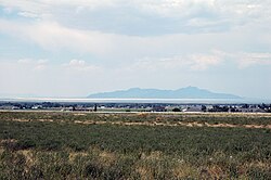
 View of Erda looking at the Great Salt Lake and Stansbury Island | |
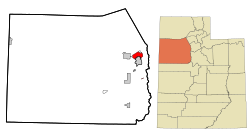
 Location in Tooele County and the state of Utah | |
 Location of Utah in the United States | |
| Coordinates: 40°36′26″N 112°18′33″W / 40.60722°N 112.30917°W | |
| Country | United States |
| State | Utah |
| County | Tooele |
| Established | 1852 |
| Granted Township Status | 1997 |
| Incorporated as a city | January 3, 2022 |
| Area | |
| • Total | 22.5 sq mi (58.2 km2) |
| • Land | 22.5 sq mi (58.2 km2) |
| • Water | 0.0 sq mi (0.0 km2) |
| Elevation | 4,344 ft (1,324 m) |
| Population (2010) | |
| • Total | 4,642 |
| • Density | 210/sq mi (80/km2) |
| Time zone | UTC-7 (Mountain (MST)) |
| • Summer (DST) | UTC-6 (MDT) |
| ZIP code | 84074 |
| Area code | 435 |
| FIPS code | 49-23640[1] |
| GNIS feature ID | 1437555[2] |
Erda (/ˈɜːrdə/ UR-də) is a city in Tooele County, Utah, United States. The population was 4,642 at the 2010 census, a significant increase from the 2000 figure of 2,473. Erda was previously a Census Designated Place (CDP) and a township but officially received its incorporation certificate in January 2022.
© MMXXIII Rich X Search. We shall prevail. All rights reserved. Rich X Search
