Back اسن يورت Arabic Əsənyurd Azerbaijani Esenyurt Breton Esenyurt Catalan Эсенйурт CE Esenyurt (distrito) CEB Esenyurt Danish Esenyurt German Esenyurt DIQ Εσενγιούρτ Greek
Esenyurt | |
|---|---|
District and municipality | |
 | |
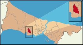
 Map showing Esenyurt District in Istanbul Province | |
| Coordinates: 41°02′03″N 28°40′48″E / 41.03417°N 28.68000°E | |
| Country | Turkey |
| Province | Istanbul |
| Government | |
| • Mayor | Ahmet Özer (CHP) |
| Area | 43 km2 (17 sq mi) |
| Population (2022)[1] | 983,571 |
| • Density | 23,000/km2 (59,000/sq mi) |
| Time zone | UTC+3 (TRT) |
| Postal code | 34510 |
| Area code | 0212 |
| Website | www |
Esenyurt (Turkish: [eˈsɛnjuɾt]), formerly known as Ksenos, is a municipality and district of Istanbul Province, Turkey.[2] Its area is 43 km2,[3] and its population is 983,571 (2022).[1] Located in the European side of Istanbul, Esenyurt borders with Avcılar and Lake Küçükçekmece on the east, Büyükçekmece on the west, Başakşehir, Arnavutköy and TEM road on the north and Beylikdüzü and E-5 motorway on the south.
With the construction boom of large residential complexes in the area in the past few years, Esenyurt benefited from a major development. It now has four cultural centres, which are Esenyurt Cultural Centre, Saadetdere Cultural Centre, Yenikent Cultural Centre and Yunus Balta Cultural Centre. Four parks built in Esenyurt (Recep Tayyip Erdoğan Park, Şehitler Park, Gaziler Park and Kadir Topbaş Park) are also situated among the complexes.
- ^ a b "Address-based population registration system (ADNKS) results dated 31 December 2022, Favorite Reports" (XLS). TÜİK. Retrieved 12 July 2023.
- ^ Büyükşehir İlçe Belediyesi, Turkey Civil Administration Departments Inventory. Retrieved 12 July 2023.
- ^ "İl ve İlçe Yüz ölçümleri". General Directorate of Mapping. Retrieved 12 July 2023.
© MMXXIII Rich X Search. We shall prevail. All rights reserved. Rich X Search

