Back Ewaso Ng'iro CEB Uaso Nyiro German Río Lagh Dera Spanish Ewaso Ng'iro French ევუასო-ნგირო Georgian Evaso Ngiras Lithuanian Ewaso Ng’iro NB Ewaso Ng'iro Polish Эвасо-Нгиро (приток Джуббы) Russian Ewaso Ng'iro Slovenian
| Ewaso Ng'iro Uaso Nyiro or Lagh Dera | |
|---|---|
 Ewaso Ng'iro in Shaba National Reserve, Kenya | |
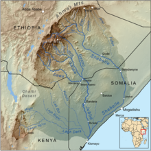
 Map of the Jubba/Shebelle drainage basin. The Ewaso Ng'iro-Lagh Dera is located in the south. | |
| Location | |
| Country | Kenya |
| Physical characteristics | |
| Source | |
| • location | Mount Kenya |
| Mouth | |
• elevation | 600 m (2,000 ft) |
| Length | 700 km |
| Basin size | 231.000 km² |

Ewaso Ng'iro, also called Ewaso Nyiro, is a river in Kenya which rises on the west side of Mount Kenya and flows north, then east and finally south-east, passing through Somalia where it joins the Jubba River.[1] The river's name is derived from the local community's language, and means river of brown or muddy water. Downstream, the intermittent stream in Somalia is also called Lagh Dera.
The upper basin of the Ewaso Ng'iro River is 15,200-square-kilometre (5,900 sq mi).[2] The river has a continuous water supply due to the glaciers on Mount Kenya. Ewaso Ng'iro feeds into Lake Ol Bolossat, the only lake in Nyandarua County and the larger Central Kenya,[3][4][5] and crosses seven arid to semi-arid landscapes. It is characterized by vastly different physiographic features and species and has become a fundamental component to the survival of the wildlife, as well as the expansion of the human population and socio-economic developments. Water, the limited land resource provided by the Ewaso Ng’iro watershed, is unevenly distributed throughout the higher and lower regions of the catchment due to the large percentage necessary to maintain agricultural practices and climatic changes (Mutiga, Su, and Woldai 3).

In the arid north of Kenya, water means life. The waters of this great river draw wildlife in great numbers to its banks, creating an oasis of green. Samburu, Shaba and Buffalo Springs National Reserves in Northern Kenya teem with wildlife in an otherwise arid land, because of the water of the river. Below Saricho, the river expands into the Lorian Swamp, a large area of wetlands.[6] The ecological diversity throughout the catchment is unique to the Ewaso Ng’iro watershed specifically, as it originates from the high agriculturally potent lands of Mount Kenya, right at Thome Area of Nanyuki-Laikipia County, that means the exact start point of this river is at the Thome village where it is formed out of convergence of Naromoru River, sourcing water from Mt. Kenya, and Ngarinyiru River sourcing water from Aberdares and it flows over the following seven arid to semi-arid land districts of Meru, Laikipia, Samburu, Isiolo, Wajir, Marsabit, and Garissa (Said et al. 14). Following the independence of Kenya, the stretches of land covered by the Ewaso Ng’iro watershed shifted ownership from the colonial farmers to small-scale farmers (Thenya et al. 2). The catchment became a main resource for the small-scale farmers to support their agropastorial practices and developing livelihoods (Thenya et al. 2).
Ewaso Narok River is one of its tributaries. Thomson's Falls near Nyahururu town is located along Ewaso Narok.
- ^ Rough Guide Map Kenya (Map) (9 ed.). 1:900,000. Rough Guide Map. Cartography by World Mapping Project. Rough Guide. 2006. ISBN 1-84353-359-6.
- ^ Makali, Samuel; Boniface Kiteme (September 2005). "The Upper Ewaso Ng'iro Basin, Kenya". Network for Water and Sanitation. Archived from the original on 2007-05-24. Retrieved 2007-06-21.
- ^ Mulli, Thorn. "Discovering Central Kenya's only natural lake". The Standard. Retrieved 2019-02-23.
- ^ "A wreath for Ewaso Ng'iro". Daily Nation. Archived from the original on 2019-02-23. Retrieved 2019-02-23.
- ^ "Why lake that feeds Ewaso was declared protected area". The Star, Kenya. Retrieved 2019-02-23.
- ^ R. H. Hughes, J. S. Hughes (1992). A directory of African wetlands. IUCN. ISBN 2-88032-949-3.
© MMXXIII Rich X Search. We shall prevail. All rights reserved. Rich X Search