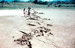

A fault trace describes the intersection of a geological fault with the Earth's surface, which leaves a visible disturbance on the surface, usually looking like a crack in the surface with jagged rock structures protruding outward. The term also applies to a line plotted on a geological map to represent a fault. These fractures tend to occur when a slip surface expands from a fault core, especially during an earthquake. This tends to occur with fault displacement, in which surfaces on both sides of a fault, known as fault blocks, separate horizontally or vertically.[1]
- ^ Torabi, Anita; Berg, Silje Støren (2011-08-01). "Scaling of fault attributes: A review". Marine and Petroleum Geology. 28 (8): 1444–1460. Bibcode:2011MarPG..28.1444T. doi:10.1016/j.marpetgeo.2011.04.003. ISSN 0264-8172.
© MMXXIII Rich X Search. We shall prevail. All rights reserved. Rich X Search
