Back نهر فلينت ARZ فلینت چایی AZB Флінт (рака) Byelorussian Флинт (река) Bulgarian Riu Flint Catalan Флинт (юханшыв) CV Flint River (Georgia) Danish Flint River (Apalachicola River) German Río Flint Spanish Flint (rivière de Géorgie) French
| Flint River | |
|---|---|
 Jim Woodruff Dam, at the mouth of the Flint River | |
 Map of the Apalachicola River system with the Flint River in dark blue and its watershed highlighted. | |
| Physical characteristics | |
| Source | Flint River |
| • location | College Park, Georgia |
| • coordinates | 33°40′08″N 84°26′24″W / 33.669°N 84.440°W |
| • elevation | 1,027 ft (313 m) |
| Mouth | Apalachicola River |
• location | Lake Seminole |
• coordinates | 30°43′44″N 84°52′30″W / 30.729°N 84.875°W |
• elevation | 77 ft (23 m) |
| Length | 344 mi (554 km) |
| Basin size | 8,460 sq mi (21,900 km2) |


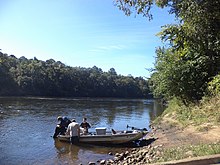
The Flint River is a 344-mile-long (554 km)[1] river in the U.S. state of Georgia. The river drains 8,460 square miles (21,900 km2) of western Georgia, flowing south from the upper Piedmont region south of Atlanta to the wetlands of the Gulf Coastal Plain in the southwestern corner of the state. Along with the Apalachicola and the Chattahoochee rivers, it forms part of the ACF basin. In its upper course through the red hills of the Piedmont, it is considered especially scenic, flowing unimpeded for over 200 miles (320 km). Historically, it was also called the Thronateeska River.[2]
- ^ U.S. Geological Survey. National Hydrography Dataset high-resolution flowline data. The National Map Archived 2012-03-29 at the Wayback Machine, accessed April 15, 2011
- ^ Thronateeska chapter, Daughters of the American revolution (1924). History and reminiscences of Dougherty county, Georgia. Albany, Georgia: Herald publishing company. p. 16.
© MMXXIII Rich X Search. We shall prevail. All rights reserved. Rich X Search