Back 18.º distrito congresional de Florida Spanish حوزه انتخابیه هجدهم فلوریدا Persian Dix-huitième district congressionnel de Floride French 佛羅里達州第十八國會選區 Chinese
| Florida's 18th congressional district | |
|---|---|
Interactive map of district boundaries since January 3, 2023 | |
| Representative | |
| Area | 1,889[1] sq mi (4,890 km2) |
| Distribution |
|
| Population (2022) | 833,693[3] |
| Median household income | $57,810[4] |
| Ethnicity |
|
| Cook PVI | R+13[5] |
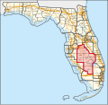
Florida's 18th congressional district is an electoral district for the U.S. Congress, located in the Florida Heartland. In the 2020 redistricting cycle, the district was redrawn to cover inland counties of DeSoto, Glades, Hardee, Hendry, Highlands, and Okeechobee, as well as most of Polk County (including Bartow, eastern Lakeland, and Winter Haven) and some of Immokalee in Collier County. It is essentially the successor to the old 15th district. The district is currently represented by Republican Scott Franklin.
From 2013 to 2023, the district was located in the Treasure Coast and contained the whole of St. Lucie County and Martin County as well as the northeastern part of Palm Beach County, and included Port St. Lucie, Fort Pierce, Stuart, and Jupiter, as well as Treasure Coast International Airport.[6] Much of this district is now the 21st district.
The 18th district was created as a result of the redistricting cycle after the 1980 census. From 1983 to 2012, it was based in South Florida. In its final configuration as a South Florida district, it included portions of Miami-Dade and Monroe counties. The Miami-Dade section included most of the city of Miami, the South Beach section of Miami Beach, and many of the southern Miami suburbs, including Coral Gables and Coral Terrace. The Monroe County section of the district included all of the Florida Keys.
- ^ "Congressional Plan--SC14-1905 (Ordered by The Florida Supreme Court, 2-December-2015)" (PDF). Florida Senate Committee on Reapportionment. Retrieved January 11, 2017.
- ^ "Congressional Districts Relationship Files (State-based)". U.S. Census Bureau. Archived from the original on April 2, 2013.
- ^ "My Congressional District".
- ^ "My Congressional District".
- ^ "2022 Cook PVI: District Map and List". Cook Political Report. Retrieved January 10, 2023.
- ^ Florida Redistricted Map, 2012 Retrieved June 14, 2013
© MMXXIII Rich X Search. We shall prevail. All rights reserved. Rich X Search

