Back フローマップ Japanese Peta aliran Malay Mapa de fluxo Portuguese செயல்வழி நிலப்படம் Tamil 流型图 Chinese

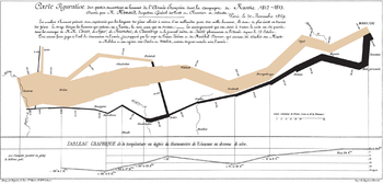
A flow map is a type of thematic map that uses linear symbols to represent movement between locations.[1] It may thus be considered a hybrid of a map and a flow diagram. The movement being mapped may be that of anything, including people, highway traffic, trade goods, water, ideas, telecommunications data, etc.[2] The wide variety of moving material, and the variety of geographic networks through they move, has led to many different design strategies. Some cartographers have expanded this term to any thematic map of a linear network, while others restrict its use to maps that specifically show movement of some kind.
Many flow maps use line width proportional to the amount of flow, making them similar to other maps that use proportional size, including cartograms (altering region area), and proportional point symbols.
- ^ Koylu, Caglar; Tian, Geng; Windsor, Mary (2023). "Flowmapper.org: a web-based framework for designing origin–destination flow maps". Journal of Maps. 19 (1). arXiv:2110.03662. doi:10.1080/17445647.2021.1996479. Retrieved 14 February 2024.
- ^ Phan, Doantam; Xiao, Ling; Yeh, Ron; Hanrahan, Pat; Winograd, Terry (2005). "Flow map layout". IEEE Symposium on Information Visualization, 2005. INFOVIS 2005. pp. 219–224. doi:10.1109/INFVIS.2005.1532150. ISBN 0-7803-9464-X.
© MMXXIII Rich X Search. We shall prevail. All rights reserved. Rich X Search