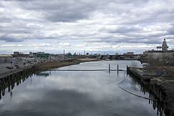
| Flushing River Flushing Creek | |
|---|---|
 The river as seen from Northern Boulevard, looking north | |
| Etymology | Flushing, Queens (from Vlissingen, Netherlands) |
| Location | |
| Country | United States |
| State | New York |
| City | New York City |
| County/Borough | Queens |
| Physical characteristics | |
| Source | Jamaica Yard |
| • coordinates | 40°43′06″N 73°49′52″W / 40.718333°N 73.831111°W |
| Mouth | Flushing Bay |
• coordinates | 40°45′54″N 73°50′36″W / 40.765115°N 73.843364°W |
| Length | 2 miles (3.2 km) |
| Basin features | |
| Tributaries | |
| • left | Horse Brook |
| • right | Kissena Creek, Mill Creek |
| Waterbodies | Meadow Lake, Willow Lake |
| Bridges | 7 |
The Flushing River, also known as Flushing Creek, is a waterway that flows northward through the borough of Queens in New York City, mostly within Flushing Meadows–Corona Park, emptying into the Flushing Bay and the East River. The river runs through a valley that may have been a larger riverbed before the last Ice Age, and it divides Queens into western and eastern halves. Until the 20th century, the Flushing Creek was fed by three tributaries: Mill Creek and Kissena Creek on the eastern bank, and Horse Brook on the western bank.
In the 18th and 19th centuries, it divided the towns of Flushing on its right bank, to the east, and Newtown (now part of Corona) on its left bank, to the west. Several bridges were built across the Flushing River in the 19th and 20th centuries. Prior to the 1939 New York World's Fair, the southern portion of the river was expanded into the Meadow and Willow Lakes. A part of the Flushing River was buried prior to the 1964 New York World's Fair. Following accumulations of pollution in the 20th century, cleanup of the Flushing River started in the 1970s, though some portions of the river have yet to be restored.
The modern-day river is 4 miles (6.4 km) long, originating near the Jamaica Yard in Kew Gardens Hills. The river flows through Willow and Meadow Lakes before entering an underground course north of the Long Island Expressway. The Flushing River runs for 2,000 feet (610 m) underground before resurfacing at the Tidal Gate Bridge at the northern end of Flushing Meadows–Corona Park. The rest of the river separates the industrial portions of the Willets Point and Flushing neighborhoods before emptying into the Flushing Bay.
© MMXXIII Rich X Search. We shall prevail. All rights reserved. Rich X Search


