Back مقاطعة فلوفانان (فيرجينيا) Arabic Fluvanna County, Virginia BAR Флувана (окръг, Вирджиния) Bulgarian ফউবান্না কাউন্টি, ভার্জিনিয়া BPY Fluvanna Gông (Virginia) CDO Флуванна (гуо, Виргини) CE Fluvanna County CEB Fluvanna County, Virginia Welsh Fluvanna County German Condado de Fluvanna Spanish
Fluvanna County | |
|---|---|
 Fluvanna County Courthouse, January 2014 | |
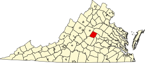
 Location within the U.S. state of Virginia | |
 Virginia's location within the U.S. | |
| Coordinates: 37°50′N 78°17′W / 37.84°N 78.28°W | |
| Country | |
| State | |
| Founded | 1777 |
| Named for | Fluvanna River |
| Seat | Palmyra |
| Largest community | Lake Monticello |
| Area | |
| • Total | 290 sq mi (800 km2) |
| • Land | 286 sq mi (740 km2) |
| • Water | 4.1 sq mi (11 km2) 1.4% |
| Population (2020) | |
| • Total | 27,249 |
| • Density | 94/sq mi (36/km2) |
| Time zone | UTC−5 (Eastern) |
| • Summer (DST) | UTC−4 (EDT) |
| Congressional district | 5th |
| Website | fluvannacounty |
Fluvanna County is a county located in the Piedmont region of the Commonwealth of Virginia, United States. As of the 2020 census, the population was 27,249.[1] Its county seat is Palmyra,[2] while the most populous community is the census designated place of Lake Monticello.
Fluvanna County is part of the Charlottesville, Virginia Metropolitan Statistical Area.
- ^ "Fluvanna County, Virginia". United States Census Bureau. Retrieved January 30, 2022.
- ^ "Find a County". National Association of Counties. Archived from the original on May 31, 2011. Retrieved June 7, 2011.
© MMXXIII Rich X Search. We shall prevail. All rights reserved. Rich X Search


