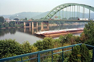
Fort Henry Bridge | |
|---|---|
 Looking towards Wheeling Island on the Fort Henry Bridge | |
| Coordinates | 40°04′19″N 80°43′39″W / 40.07194°N 80.72750°W |
| Carries | |
| Crosses | Ohio River main channel |
| Locale | Wheeling, West Virginia |
| Maintained by | West Virginia Department of Transportation |
| ID number | 00000000035A061 |
| Characteristics | |
| Design | Tied arch bridge |
| Total length | 1,660 feet (506 m) |
| Width | 53.5 feet (16 m) |
| Longest span | 580 feet (176.8 m) |
| History | |
| Opened | September 8, 1955 |
| Statistics | |
| Daily traffic | 60,070 (2009) |
| Location | |
 | |
| References | |
| [1][2][3] | |
The Fort Henry Bridge is a crossing of the Ohio River main channel in Wheeling, West Virginia. The tied-arch bridge carries two lanes in each direction of Interstate 70 (I-70), U.S. Route 40 (US 40), and US 250. The bridge opened after four years of construction work on September 8, 1955, costing $6.8 million, $1.8 million over budget. The bridge, along with the aging Wheeling Suspension Bridge, are the only two road links from Wheeling Island to downtown Wheeling, although this is the only one that allows vehicular traffic. In 2009, the structure carried an average of over 60,000 vehicles per day.
- ^ "00000000035A061". National Bridge Inventory. Federal Highway Administration. Retrieved January 29, 2011. [dead link]
- ^ I70 - Ohio to Pennsylvania (PDF) (Map). West Virginia Department of Transportation. 2009. Archived from the original (PDF) on July 21, 2011. Retrieved January 29, 2011.
- ^ Cite error: The named reference
openingwas invoked but never defined (see the help page).
© MMXXIII Rich X Search. We shall prevail. All rights reserved. Rich X Search
