Back Fort Manoel Catalan Fort Manoel German Φρούριο Μανοέλ Greek Manoelin linnoitus Finnish Fort Manoel French Benteng Manoel ID Forte Manoel Italian Fort Manoel Dutch Fort Manoel NB Fort Manoel Polish
| Fort Manoel | |
|---|---|
Forti Manoel | |
| Manoel Island, Gżira, Malta[a] | |
 View of Fort Manoel from the sea | |
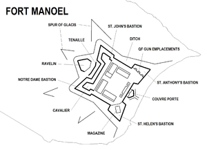
 Map of Fort Manoel | |
| Coordinates | 35°54′10″N 14°30′19″E / 35.90278°N 14.50528°E |
| Type | Star fort |
| Site information | |
| Owner | Government of Malta |
| Controlled by | MIDI plc |
| Open to the public | Yes |
| Condition | Intact |
| Site history | |
| Built | 1723–1733[b] |
| Built by | Order of Saint John |
| In use | c. 1734–1964 |
| Materials | Limestone |
| Battles/wars | French invasion of Malta (1798) Siege of Malta (1798–1800) World War II |
Fort Manoel (Maltese: Forti Manoel or Fortizza Manoel) is a star fort on Manoel Island in Gżira, Malta. It was built in the 18th century by the Order of Saint John, during the reign of Grand Master António Manoel de Vilhena, after whom it is named. Fort Manoel is located to the north west of Valletta, and commands Marsamxett Harbour and the anchorage of Sliema Creek. The fort is an example of Baroque architecture, and was designed with both functionality and aesthetics in mind.
After a brief French occupation which began in 1798, the British military took over the fort in 1800, and it remained in their use until 1964. The fort was severely damaged in World War II, but it was restored in the early 21st century and is now in good condition.
Fort Manoel has been on Malta's tentative list of UNESCO World Heritage Sites since 1998, as part of the Knights' Fortifications around the Harbours of Malta.[1]
Cite error: There are <ref group=lower-alpha> tags or {{efn}} templates on this page, but the references will not show without a {{reflist|group=lower-alpha}} template or {{notelist}} template (see the help page).
- ^ "Knights' Fortifications around the Harbours of Malta". UNESCO Tentative List. Retrieved 15 July 2015.
© MMXXIII Rich X Search. We shall prevail. All rights reserved. Rich X Search