Back Fort Severn Finnish Première Nation de Fort Severn French Fort Severn i Ontario NN Primeira Nação de Fort Severn Portuguese
Fort Severn 89
ᐗᔕᐦᐅ ᐃᓂᓂᐗᐠ | |
|---|---|
| Fort Severn Indian Reserve No. 89 | |
| Western Swampy Cree transcription(s) | |
| • Canadian Aboriginal Syllabics | Waśaho Ininiwak |
| Coordinates: 55°59′33″N 87°38′06″W / 55.99250°N 87.63500°W | |
| Country | |
| Province | |
| District | Kenora |
| First Nation | Fort Severn |
| Government | |
| • Type | Band council |
| Area | |
| • Land | 44.07 km2 (17.02 sq mi) |
| Population (2016)[2] | |
| • Total | 361 |
| • Density | 8.2/km2 (21/sq mi) |
| Website | fortsevern.firstnation.ca |


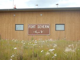
Fort Severn First Nation (Swampy Cree: ᐗᔕᐦᐅ ᐃᓂᓂᐗᐠ, romanized: Waśaho Ininiwak) is a Western Swampy Cree First Nation band government located on the Severn River near Hudson Bay. It is the most northern community in Ontario, Canada. In 2001, the population was 401, consisting of 90 families in an area of 40 square kilometres. The legal name of the reserve is Fort Severn 89, with the main settlement of Fort Severn (Swampy Cree: ᐗᔕᐦᐅᐠ, romanized: Waśahohk; Severn Ojibwa: ᐙᔕᐦᐅᐤ, romanized: wâšahow).
The town is linked by a winter/ice road called the Wapusk Trail during the winter to Peawanuck, Ontario, in the east, and Shamattawa and Gillam, Manitoba, to the west.
Fort Severn is policed by the Nishnawbe-Aski Police Service, an Indigenous-based service.
- ^ "Fort Severn 89 census profile". 2011 Census of Population. Statistics Canada. 8 February 2012. Archived from the original on 11 June 2015. Retrieved 27 May 2015.
- ^ "Fort Severn 89 census profile". 2016 Census of Population. Statistics Canada. Archived from the original on 4 December 2023. Retrieved 20 May 2016.
© MMXXIII Rich X Search. We shall prevail. All rights reserved. Rich X Search
