Back Fortificacions de Xi'an Catalan Stadtmauer von Xi’an German Muralla de la ciudad de Xi'an Spanish Xi'ango harresia Basque Remparts de Xi'an French Սիան քաղաքի ամրություններ Armenian Tembok Kota Xi'an ID 시안성벽 Korean Сиански градски ѕидини Macedonian Xi’ans befestninger NB
| Fortifications of Xi'an Xi'an City Wall | |
|---|---|
西安城墙 | |
 Xi'an City Wall | |
 | |
| General information | |
| Type | Fortification |
| Country | People's Republic of China |
| Coordinates | 34°15′58″N 108°56′35″E / 34.266°N 108.943°E |
| Technical details | |
| Size | 14 km (8.7 mi) |
| Official name | Xi'an City Wall |
| Type | Cultural |
| Criteria | iii, iv |
| Designated | Tentative 2008 |
| Reference no. | [1] |
| Region | Tentative Asia-Pacific |
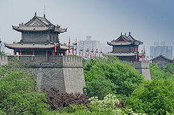
The fortifications of Xi'an (Chinese: 西安城墙), also known as Xi'an City Wall, in Xi'an, represent one of the oldest, largest and best preserved Chinese city walls. It was built under the rule of the Hongwu Emperor Zhu Yuanzhang as a military defense system. It exhibits the "complete features of the rampart architecture of feudal society".[1] It has been refurbished many times since it was built in the 14th century, thrice at intervals of about 200 years in the later half of the 1500s and 1700s, and in recent years in 1983. The wall encloses an area of about 14 square kilometres (5.4 sq mi).
The Xi'an City Wall is on the tentative list of UNESCO's World Heritage Site under the title "City Walls of the Ming and Qing Dynasties". Since 2008, it is also on the list of the State Administration of Cultural Heritage of the People's Republic of China. Since March 1961, the Xi'an City Wall is a heritage National Historical and Cultural Unit.
- ^ "City Walls of the Ming and Qing Dynasties Description". UNESCO Organization. Retrieved 15 November 2015.
© MMXXIII Rich X Search. We shall prevail. All rights reserved. Rich X Search