Back نهر فوكس ARZ فوخ چایی (ویسکونسین) AZB Fox River (suba sa Tinipong Bansa, Wisconsin, Brown County) CEB Fox River (Michigansee) German Fox River (Wisconsin) French Râul Fox (Wisconsin) Romanian
| Fox River | |
|---|---|
 | |
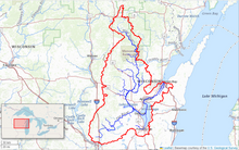
 Map of the Fox River watershed | |
| Location | |
| Country | United States |
| State | Wisconsin |
| Physical characteristics | |
| Source | Near Friesland |
| • coordinates | 43°36′54″N 89°04′05″W / 43.615°N 89.068°W |
| • elevation | 890 ft (270 m) |
| Mouth | Green Bay / Lake Michigan |
• coordinates | 44°32′24″N 88°00′18″W / 44.54°N 88.005°W |
• elevation | 577 ft (176 m) |
| Length | 200 mi (320 km) |
| Basin size | 6,429 sq mi (16,650 km2) |
| Discharge | |
| • average | 4,132 cu ft/s (117.0 m3/s) |
| Basin features | |
| River system | St. Lawrence River system |
| Tributaries | |
| • left | Wolf River |


The Fox River is a river in eastern Wisconsin in the Great Lakes region of the United States. It is the principal tributary of Green Bay, and via the Bay, the largest tributary of Lake Michigan. The city of Green Bay, one of the first European settlements in the interior of North America, is on the river at its mouth on lower Green Bay.
Hydrographers divide the Fox into two distinct sections, the Upper Fox River, flowing from its headwaters in south-central Wisconsin northeasterly into Lake Winnebago, and the Lower Fox River, flowing from Lake Winnebago northeasterly to lower Green Bay. Together, the two sections give the Fox River a length of 182 miles (293 km).[1] Counting the distance through Lake Winnebago gives a total of 200 miles (322 km).[1]
The Fox River (Green Bay tributary) should not be confused with the Fox River (Illinois River tributary) which also flows through Wisconsin having its origin starting at a point approximately 10 miles northwest of Menomonee Falls, Wisconsin, and flowing through the cities of Waukesha, Mukwonago and Burlington, before flowing out of Wisconsin into Illinois. The Fox River (Illinois tributary) is the longer of the two rivers flowing from southeast Wisconsin and terminating in Ottawa, Illinois where it joins the Illinois River, for an estimated journey of 202 miles (325 km).[citation needed]
The river's name is the English translation of the French name for the Meskwaki people in the 17th century. The river was part of the famous 1673–74 expedition of Jolliet and Marquette, in which they went on to become the first Europeans to traverse the upper Mississippi River. A particular set of cities on the lower Fox River identify themselves as the "Fox Cities".
- ^ a b U.S. Geological Survey. National Hydrography Dataset high-resolution flowline data. The National Map Archived 2012-03-29 at the Wayback Machine, accessed December 19, 2011
© MMXXIII Rich X Search. We shall prevail. All rights reserved. Rich X Search