Back فرينتش (جزيره) ARZ French Island (pulo sa Ostralya) CEB French Island (Victoria) German جزیره فرانسوی (ویکتوریا) Persian French Island French French Island (Victoria) Italian French Island (Victoria) NB Ilha French (Victoria) Portuguese Френч (остров) Russian French Island (Victoria) SIMPLE
This article needs additional citations for verification. (May 2023) |
| French Island Bellarmarin (Boonwurrung) Victoria | |
|---|---|
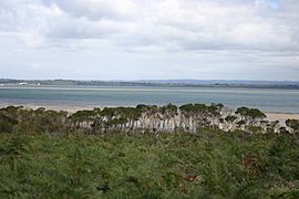
 Looking west over Western Port to Mornington Peninsula from the coast road | |
Location near Bass Coast Shire | |
| Coordinates | 38°21′00″S 145°22′12″E / 38.35000°S 145.37000°E |
| Population | 139 (2021 census)[1] |
| • Density | 0.818/km2 (2.12/sq mi) |
| Postcode(s) | 3921 |
| Area | 170 km2 (65.6 sq mi) |
| LGA(s) | Unincorporated area |
| State electorate(s) | Hastings[2] |
| Federal division(s) | Flinders |
French Island (Boonwurrung: Bellarmarin, Woone, or Jouap)[3] is the largest coastal island of Victoria, Australia, located in Western Port, 61 km (38 mi) southeast of Melbourne. In 1997, about 70% of the island was declared the French Island National Park, administered by Parks Victoria, and was listed in the former Register of the National Estate in 1984.[4] The island is an unincorporated area under the direct administration of the government of Victoria, and is a declared locality of Victoria having its own postcode. Community issues are dealt by the French Island Community Association. The island is otherwise administered by the Department of Transport and Planning. The population of the island in 2011 was around 116 people,[1] of which about 60 were permanent residents. By 2021 the population on census night was recorded as 139 with a median age of 52 years.[5]
Compared with Philip Island and areas on the surrounding mainland, French Island is isolated and undeveloped. There are no water mains, electricity mains, or medical services on the island. There is one small general store and post office located on Tankerton Road about 3 km (1.9 mi) from Tankerton Jetty. Many of the locals actively promote environmental tourism. Visitor accommodation includes camping, bed and breakfast, guesthouse and farmstay.
- ^ a b Australian Bureau of Statistics (28 June 2022). "French Island (Statistical Local Area)". 2021 Census QuickStats. Retrieved 17 October 2012.
- ^ "Hastings District Profile". Victorian Electoral Commission. Retrieved 15 June 2018.
- ^ Clark, Ian D, 2014, Ch 13. Multiple Aboriginal placenames in western and central Victoria in Indigenous and Minority Placenames Australian and International Perspectives, ANU Press Library, Canberra, http://press-files.anu.edu.au/downloads/press/p286811/html/ch13.xhtml
- ^ "French Island and Environs, Tankerton, VIC, Australia - listing on the now-defunct Register of the National Estate (Place ID 3504)". Australian Heritage Database. Australian Government. 27 March 1984. Retrieved 24 November 2019.
- ^ "2021 French Island, Census All persons QuickStats | Australian Bureau of Statistics".
© MMXXIII Rich X Search. We shall prevail. All rights reserved. Rich X Search
