Back جان (جزيره) ARZ Gan Island (pulo sa Maldibs) CEB Gan (Addu-Atoll) German ގަން (އައްޑުއަތޮޅު) DV Gan (Addu) Spanish ガン島 Japanese Gan (Seenu-atol) Dutch Ган (остров) Russian Gan (Sínu) Slovak Gan (Adduatollen) Swedish
This article needs additional citations for verification. (September 2013) |
Gan | |
|---|---|
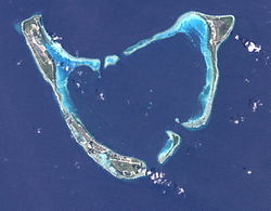
 Addu Atoll seen from space. Gan lies at the end of the continuous reef fringing Addu from the west and southwest | |
 1976 map of Addu Atoll showing Gan and airfield | |
| Coordinates: 00°41′40″S 073°09′18″E / 0.69444°S 73.15500°E | |
| Country | Maldives |
| Geographic atoll | Addu Atoll |
| Distance to Malé | 258.48 km (160.61 mi) |
| Area | |
| • Total | 2.256 km2 (0.871 sq mi) |
| Dimensions | |
| • Length | 1.000 km (0.621 mi) |
| • Width | 0.330 km (0.205 mi) |
| Population | |
| • Total | 1,104 |
| • Density | 490/km2 (1,300/sq mi) |
| Time zone | UTC+05:00 (MST) |
Gan (Dhivehi: ގަން) is the southernmost island of Addu Atoll (also known as Seenu Atoll), as well as the southernmost island of the Maldives. It is relatively large by Maldive standards.
The origin of the word "Gan" is in the Sanskrit word "Grama", meaning "village".
Gan is the second largest island of the atoll, after Hithadhoo, and measures 2.2561 square kilometres (0.87 sq mi) in area. Gan was formerly inhabited, but its inhabitants were moved to neighbouring islands after the British naval and airbase was built. It has had continuous human habitation since very ancient times and during the pre-Islamic era was the head island and a Buddhist place of learning in Addu. There were large cultivated fields of yams, manioc and coconut trees on this island. There were a few mosques in the village. A former havitta at island's east end had to be removed to build the runway.
Gan now has a hotel catering to tourists and is connected by causeways to the neighbouring islands of Feydu, Maradu and Hithadhoo.
© MMXXIII Rich X Search. We shall prevail. All rights reserved. Rich X Search
