Back Qaraxonay Milli Parkı Azerbaijani Taman Nasional Garajonay BAN Гарахонай Bulgarian গ্যারাহনেই জাতীয় উদ্যান Bengali/Bangla Parc Nacional de Garajonay Catalan Garajonay National Park CEB Garajonay Czech Garajonay Nationalpark Danish Nationalpark Garajonay German Nacia Parko Garajonay Esperanto
| Garajonay National Park | |
|---|---|
.jpg) | |
 Location of Garajonay | |
| Location | La Gomera, Canary Islands, Spain |
| Coordinates | 28°07′34″N 17°14′14″W / 28.12611°N 17.23722°W |
| Area | 40 km2 (15 sq mi) |
| Established | 1981 |
| Type | Natural |
| Criteria | vii, ix |
| Designated | 1986 (10th session) |
| Reference no. | 380 |
| Region | Europe and North America |
Garajonay National Park (Spanish: Parque nacional de Garajonay, pronounced [ˈpaɾke naθjoˈnal de ɣaɾaxoˈnaj]) is located in the center and north of the island of La Gomera, one of the Canary Islands (Spain). It was declared a national park in 1981 and a World Heritage Site by UNESCO in 1986. It occupies 40 km2 (15 sq mi) and it extends into each of the six municipalities on the island.
Nearly 450,000 tourists visit the park every year. There is accommodation for tourists just outside the park's boundary.[1]
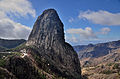
The park is named after the rock formation of Garajonay, the highest point on the island at 1,487 metres (4,879 ft). It also includes a small plateau whose altitude is 790–1,400 metres (2,590–4,590 ft) above sea level. Features of the national park include the massive rocks that are found along the island. These are former volcanoes whose shapes have been carved by erosion. Some, like the "Fortaleza" (fortress in Spanish) were considered sacred by the native islanders, as well as ideal refuges when attacked.[2] The park is crossed by a large network of 18 footpaths, trekking being one of the main tourist activities in the island.
-
 Roque Ojila
 -
-
 Roque de La Zarcita


- ^ 갈라호네이국립공원. www.doopedia.co.kr (in Korean). Retrieved 2018-04-16.
- ^ Carracedo, J. C. (Juan Carlos); Troll, V. R. (26 May 2016). The geology of the Canary Islands. Amsterdam, Netherlands. ISBN 978-0-12-809664-2. OCLC 951031503.
{{cite book}}: CS1 maint: location missing publisher (link)
© MMXXIII Rich X Search. We shall prevail. All rights reserved. Rich X Search