Back Xeografía de Barbados AST Geografía de Barbados Spanish جغرافیای باربادوس Persian Géographie de la Barbade French Barbadoso geografija Lithuanian Geografia Barbadosu Polish Geografia de Barbados Portuguese Географія Барбадосу Ukrainian
Nickname: Bimshire or Little England | |
|---|---|
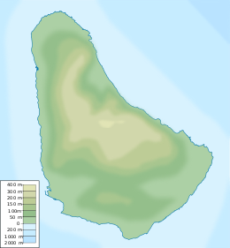
 Map of Barbados | |
| Geography | |
| Location | Atlantic Ocean |
| Coordinates | 13°10′N 59°33′W / 13.167°N 59.550°W |
| Area | 439 km2 (169 sq mi) |
| Length | 34 km (21.1 mi) |
| Width | 24 km (14.9 mi) |
| Coastline | 97 km (60.3 mi) |
| Highest elevation | 336 m (1102 ft) |
| Highest point | Mount Hillaby |
| Administration | |
| Largest settlement | Bridgetown (pop. 96,578) |
| Demographics | |
| Population | 279,000 (2006) |
| Pop. density | 648.84/km2 (1680.49/sq mi) |
| Ethnic groups | 90% Afro-Caribbean, 4% European, 6% Asian and Multiracial |
Barbados is a continental island in the North Atlantic Ocean and is located at 13°10' north of the equator, and 59°32' west of the Prime Meridian. As the easternmost isle of the Lesser Antilles in the West Indies, Barbados lies 160 kilometres (100 mi) east of the Windward Islands and Caribbean Sea.[1] The maritime claim for Barbados is a territorial sea of 12 nmi (22.2 km; 13.8 mi), with an exclusive economic zone of 200 nmi (370.4 km; 230.2 mi) which gives Barbados a total maritime area of 186,898 km2 (72,162 sq mi).[2] Of the total EEZ area, 70,000 km2 is set aside for offshore oil exploration.[3] A pending application to UNCLOS has placed for consideration a continental shelf 200 nmi (370.4 km; 230.2 mi) to the east and south (or to the edge of the continental margin). To the west, most of Barbados' maritime boundaries consist of median lines with neighbours. These neighbours include: Martinique, and Saint Lucia to the northwest, Saint Vincent and the Grenadines to the west, Trinidad and Tobago and Venezuela to the southwest, and Guyana to the southeast.

Barbados' total land area is 439 km2 (169.5 sq mi),[4] and it has a coastline of 97 km (60 mi) length.[5] The island is sometimes compared to a pear[6] or leg of mutton for its physical shape. Barbados has a maximum north–south length of 34 kilometres (21 mi) and a maximum east–west breadth of 23 kilometres (14 mi).
- ^ "Windward Islands". Encyclopædia Britannica.
a line of West Indian islands constituting the southern arc of the Lesser Antilles, at the eastern end of the Caribbean Sea, between latitudes 12° and 16° N and longitudes 60° and 62° W. They include, from north to south, the English-speaking island of Dominica; the French département of Martinique; the English-speaking islands of Saint Lucia, Saint Vincent, and Grenada; and, between Saint Vincent and Grenada, the chain of small islands known as the Grenadines. Though near the general area, Trinidad and Tobago (at the south end of the group) and Barbados (just east) are usually not considered part of the Windward Islands.
- ^ Joseph, Cedric. "Border Controversies and their Implications for Stability and Security of the Caribbean Community". UWI-CARICOM Project. Archived from the original on 2014-10-22.
The Bahamas, one of six CARICOM States to claim archipelago status, with a total coastline of 11,238 km, is reported to have the largest claim to EEZ of 369,149 sq km. Barbados, with a total coastline of some 97 km and a relatively small continental shelf of 213 sq km, reportedly has a claim to some 183,436 sq km of exclusive economic zone.
- ^ Staff writer (8 August 2007). "BID Blocks carrying local names". Government of Barbados. Archived from the original on October 3, 2011. Retrieved 20 December 2010.
Barbados is 341(TYPO?) square kilometres in size and 70,000 sq km of its marine territorial space has been made available for the offshore hydrocarbon exploration. This means that the acreage on the market is about 162 times the size of the island's land space.
- ^ "Barbados country profile". BBC News. 2012-08-02. Retrieved 2023-10-02.
- ^ "DSD :: Areas of Work :: SIDS - SIDS Members - the Caribbean".
- ^ Pariser, Harry S. (October 2000). Explore Barbados. Vol. 3. Manatee Press. ISBN 1-893643-51-4. Retrieved 2009-12-29.
Forewords & Introductions: "Just 21 mi. long by a "smile" wide, Barbados is an island of dramatic contrasts and offers many picture-postcard terrains. The island's shape has been compared to that of a ham, a leg of mutton, a pear-shaped emerald, or a lopsided pear with the stem end pointing north.
© MMXXIII Rich X Search. We shall prevail. All rights reserved. Rich X Search


