Back جغرافيا كيريباتي Arabic Xeografía de Kiribati AST География на Кирибати Bulgarian কিরিবাসের ভূগোল Bengali/Bangla Geografía de Kiribati Spanish جغرافیای کیریباتی Persian Kiribatin maantiede Finnish Géographie des Kiribati French Zemljopis Kiribatija Croatian Geografi Kiribati ID
1°25′N 173°00′E / 1.417°N 173.000°E
 | |
| Region | Oceania |
|---|---|
| Coordinates | 1°25′N 173°00′E / 1.417°N 173.000°E |
| Area | Ranked 172nd |
| • Total | 811 km2 (313 sq mi) |
| • Land | .1% |
| • Water | 99.9% |
| Coastline | 1,143 km (710 mi) |
| Borders | None |
| Highest point | Unnamed location on Banaba 81 m (266 ft)[1] |
| Lowest point | Sea Level, 0 m (0 ft) |
| Climate | Maritime |
| Terrain | Atolls |
| Natural resources | Guano, fish, coconuts, petroleum |
| Natural hazards | Cyclones, |
| Environmental issues | rising sea levels |
| Exclusive economic zone | 3,441,810 km2 (1,328,890 sq mi) |
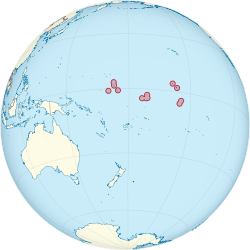
Kiribati consists of 32 atolls and one island in an expanse of ocean equivalent in size to the contiguous United States. The islands are scattered such that Kiribati has territory located in each of the four hemispheres. The islands of Kiribati lie roughly halfway between Hawaii and Australia in the Micronesian and Polynesian regions of the South Pacific. The three main island groupings are the Gilbert Islands, Phoenix Islands, and Line Islands. On 1 January 1995 Kiribati moved the International Date Line to include its easternmost islands and make it the same day throughout the country.
- ^ "19. Banaba" (PDF). Office of Te Beretitent - Republic of Kiribati Island Report Series. 2012. Archived from the original (PDF) on 23 September 2015. Retrieved 28 April 2015.
© MMXXIII Rich X Search. We shall prevail. All rights reserved. Rich X Search