Back جغرافيا مونتسيرات Arabic Geografía de Montserrat Spanish Geografia Montserratu Polish Географія Монтсеррату Ukrainian
This article was imported from the CIA's World Factbook. |
Nickname: The Emerald Isle of the Caribbean | |
|---|---|
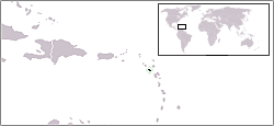
 Map of Montserrat | |
 | |
| Geography | |
| Location | Caribbean Sea |
| Coordinates | 16°45′N 62°12′W / 16.750°N 62.200°W |
| Archipelago | Leeward Islands |
| Area | 102 km2 (39 sq mi) |
| Coastline | 39.8 km (24.73 mi) |
| Highest elevation | 914.2 m (2999.3 ft) |
| Highest point | Chances Peak (in the Soufrière Hills) |
| Administration | |
United Kingdom | |
| British Overseas Territory | Montserrat |
| Largest settlement | Brades (pop. 1,000) |
| Demographics | |
| Population | 4,488 |
| Pop. density | 44.88/km2 (116.24/sq mi) |

Montserrat is an island in the Caribbean Sea, in the Leeward Islands. Its nearest neighbours in the island chain include Guadeloupe to the southeast, Antigua to the north-east and Nevis to the northwest. The island is 16 km (9.9 mi) long and 11 km (6.8 mi) wide, with a coastline of about 40 km.
The island is volcanic and largely mountainous. The Soufrière Hills volcano became active in 1995, causing widespread devastation, including the destruction of the capital and formerly largest settlement on the island, Plymouth. The southern part of the island is now uninhabitable and human settlement is constrained to the north.
Montserrat has two islets, Little Redonda and Virgin, as well as Statue Rock.
© MMXXIII Rich X Search. We shall prevail. All rights reserved. Rich X Search