Back جغرافيا زيمبابوي Arabic География на Зимбабве Bulgarian জিম্বাবুয়ের ভূগোল Bengali/Bangla Γεωγραφία της Ζιμπάμπουε Greek Geografía de Zimbabue Spanish جغرافیای زیمبابوه Persian Zimbabwen maantiede Finnish Géographie du Zimbabwe French Ọdịdị ala nke Zimbabwe IG Geografia dello Zimbabwe Italian
This article needs additional citations for verification. (October 2014) |
  | |
| Continent | Africa |
|---|---|
| Region | Southern Africa |
| Coordinates | 20°S 30°E / 20°S 30°E |
| Area | Ranked 60th |
| • Total | 390,757 km2 (150,872 sq mi) |
| • Land | 99.00% |
| • Water | 1.00% |
| Coastline | 0 km (0 mi) |
| Borders | 3,066 km (Botswana 813 km, Mozambique 1231 km, South Africa 225 km, Zambia 797 km) |
| Highest point | Inyangani 2,592 m (8,504 ft) |
| Lowest point | junction of the Runde and Save rivers. 162 m (531 ft) |
| Longest river | Zambezi River 2,650 km |
| Largest lake | Lake Kariba 7,770 km2 |


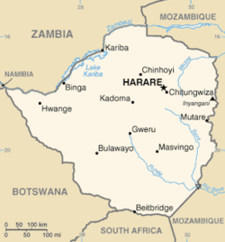
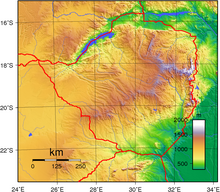
Zimbabwe is a landlocked country in southern Africa lying north of the Tropic of Capricorn.[1] During summer, the whole country experiences warm temperatures as a result of the sun being directly overhead. It straddles an extensive high inland plateau that drops northwards to the Zambezi valley where the border with Zambia is and similarly drops southwards to the Limpopo valley and the border with South Africa.
- ^ "Zimbabwe climate: average weather, temperature, precipitation, when to go, what to pack". www.climatestotravel.com. Retrieved 2023-05-14.
© MMXXIII Rich X Search. We shall prevail. All rights reserved. Rich X Search