Back جغرافيا جزر القمر Arabic Xeografía de Comores AST Daearyddiaeth y Comoros Welsh Geografía de Comoras Spanish جغرافیای کومور Persian Géographie des Comores French Zemljopis Komora Croatian Geografia delle Comore Italian Komorų geografija Lithuanian Jeôgrafian' i Kômôro Malagasy
12°10′S 44°15′E / 12.167°S 44.250°E
This article needs additional citations for verification. (October 2012) |


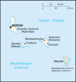
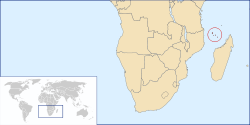
The Comoros archipelago consists of four main islands aligned along a northwest–southeast axis at the north end of the Mozambique Channel, between Mozambique and the island of Madagascar. Still widely known by their French names, the islands officially have been called by their Swahili names by the Comorian government. They are Grande Comore (Njazidja), Mohéli (Mwali), Anjouan (Nzwani), and Mayotte (Mahoré). The islands' distance from each other—Grande Comore is some 200 kilometers from Mayotte, forty kilometers from Mohéli, and eighty kilometers from Anjouan—along with a lack of good harbor facilities, make transportation and communication difficult. Comoros are sunny islands.
© MMXXIII Rich X Search. We shall prevail. All rights reserved. Rich X Search