Back George Street (Sydney) AN George Street (Sídney) Spanish George Street (Sydney) Italian George Street, Sydney Malay جارج اسٹریٹ، سڈنی Urdu 佐治街 (雪梨) Chinese
George Street | |
|---|---|
 | |
| George Street in its current state after the implementation of light rail | |
 | |
| Coordinates | |
| General information | |
| Type | Street |
| Length | 3 km (1.9 mi) |
| Former route number | (Ultimo–Town Hall) |
| Major junctions | |
| North end | Lower Fort Street Dawes Point, Sydney |
| South end | Ultimo, Sydney |
| Location(s) | |
| Suburb(s) | Sydney CBD, Haymarket |
| ---- | |
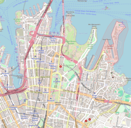
George Street is a street in the central business district of Sydney.
It was Sydney's original high street, and remains one of the busiest streets in the city centre. It connects a number of the city's most important buildings and precincts. There are more high rise buildings here than on any other street in Australia. Amongst Australia's 100 largest listed companies, more are located here than on any other street.
The street begins in the north end of Sydney in The Rocks, near the Sydney Harbour Bridge, and extends to the southern end of the city, near Central Station and Ultimo, where it leads into Railway Square. From here Broadway is the continuation of George Street turning westwards, leading to the western suburbs as Parramatta Road.
© MMXXIII Rich X Search. We shall prevail. All rights reserved. Rich X Search
