Back Ghanzidistrik Afrikaans مقاطعة غانزي Arabic Distritu de Ghanzi AST Ганзі (акруга) Byelorussian Ганзі (акруга) BE-X-OLD Ганзи Bulgarian Ghanzi (distrig) Breton Ghanzi District CEB Ghanzi District German Περιφέρεια Γκάνζι Greek
Ghanzi
Gantsi | |
|---|---|
 | |
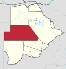
 Location within Botswana | |
| Coordinates: 22°00′S 22°00′E / 22.000°S 22.000°E | |
| Country | |
| Capital | Ghanzi |
| Area | |
| • Total | 117,910 km2 (45,530 sq mi) |
| Population (2011 census) | |
| • Total | 43,370 |
| • Density | 0.37/km2 (0.95/sq mi) |
| Time zone | UTC+2 (Central Africa Time) |
| HDI (2017) | 0.666[1] medium · 10th |
Ghanzi (sometimes Gantsi) is a district in western Botswana, bordering Namibia in the west and extending east into much of the interior of the country. The district's administrative centre is the town of Ghanzi. Most of the eastern half of Ghanzi makes up the Central Kalahari Game Reserve. The human population at the 2001 census was 43,370, less populous than that of any other district in Botswana. Ghanzi's area is 117,910 km².
In the west, Ghanzi borders the Omaheke Region of Namibia. Domestically, it borders the following districts: North-West on the north, Central on the east, Kweneng on the southeast, Kgalagadi on the south. Ghanzi, Central Kalahari Game Reserve, Deception Valley, Ghanzi Craft, Kgalagadi Transfrontier Park and Khutse Game Reserve are the major game areas in the district.
The district is administered by a district administration and district council which are responsible for local administration.
- ^ "Sub-national HDI - Area Database - Global Data Lab". hdi.globaldatalab.org. Retrieved 2018-09-13.
© MMXXIII Rich X Search. We shall prevail. All rights reserved. Rich X Search