Back ጎልበርን (ከተማ) Amharic غولبرن (نيوساوث ويلز) Arabic جولبرن ARZ قولبورن، یئنی گونئی ولز AZB Goulburn CEB گوولبۆرن، نیو ساوت وێلز CKB Goulburn Czech Goulburn Welsh Goulburn (New South Wales) Danish Goulburn German
| Goulburn New South Wales | |||||||||||||||
|---|---|---|---|---|---|---|---|---|---|---|---|---|---|---|---|
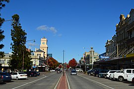
 Goulburn city centre | |||||||||||||||
 | |||||||||||||||
| Coordinates | 34°45′17″S 149°37′7″E / 34.75472°S 149.61861°E | ||||||||||||||
| Population | 24,565 (2021)[1] | ||||||||||||||
| Established | 1833 | ||||||||||||||
| Postcode(s) | 2580 | ||||||||||||||
| Elevation | 642 m (2,106 ft) | ||||||||||||||
| Location | |||||||||||||||
| LGA(s) | Goulburn Mulwaree Council | ||||||||||||||
| County | Argyle | ||||||||||||||
| Parish | Goulburn | ||||||||||||||
| State electorate(s) | Goulburn | ||||||||||||||
| Federal division(s) | Hume | ||||||||||||||
| |||||||||||||||
| |||||||||||||||
Goulburn (/ˈɡoʊlbərn/ GOHL-bərn) is a regional city in the Southern Tablelands of New South Wales, Australia, approximately 195 kilometres (121 mi) south-west of Sydney and 90 kilometres (56 mi) north-east of Canberra. It was proclaimed as Australia's first inland city through letters patent by Queen Victoria in 1863. Goulburn had a population of 24,565 at June 2021.[1] Goulburn is the seat of Goulburn Mulwaree Council.
Goulburn is a railhead on the Main Southern line, and regional health & government services centre, supporting the surrounding pastoral industry as well as being a stopover for travellers on the Hume Highway. It has a central historic park and many historic and listed buildings. It is also home to the monument the Big Merino, a sculpture that is the world's largest concrete-constructed sheep.
- ^ a b "3218.0 – Regional Population Growth, Australia, 2017-18: Population Estimates by Significant Urban Area, 2008 to 2018". Australian Bureau of Statistics. Australian Bureau of Statistics. 27 March 2019. Retrieved 22 April 2019. Estimated resident population, 30 June 2018.
© MMXXIII Rich X Search. We shall prevail. All rights reserved. Rich X Search
