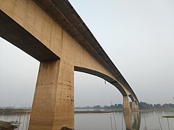
Gouranga Bridge গৌরাঙ্গ সেতু | |
|---|---|
 Gouranga Bridge in 2020 | |
| Coordinates | 23°23′09″N 88°22′00″E / 23.385928°N 88.366555°E |
| Carries | Motor vehicles, pedestrians and bicycles |
| Crosses | Bhagirathi River |
| Locale | Nabadwip, Nadia, West Bengal, India |
| Official name | Gouranga Setu |
| Named for | Chaitanya Mahaprabhu |
| Owner | PWD |
| Maintained by | PWD Burdwan Division-I (till 2016) PWD Nadia Division-I (since 2016) |
| Characteristics | |
| Design | Bored piling method |
| Material | Concrete |
| Total length | 558 m (1,831 ft) |
| History | |
| Constructed by | Gammon India Limited |
| Construction start | 1972 |
| Construction end | January 1983 |
| Opened | January 16, 1983 |
| Statistics | |
| Daily traffic | Goods and passenger cars |
| Toll | Yes[1] |
| Location | |
 | |
Gouranga Bridge is a 588 m (1,929 ft) long Road bridge that crosses the Bhagirathi River in between Nabadwip and Krishnanagar, Nadia in West Bengal.[2] It is the part of State highway 8.[3]
- ^ Public Works Department, Government of West Bengal (2020-12-16). "Collection of Toll on Shree Gouranga Setu over river Bhagirathi at Nabadwip in the District of Nadia" (PDF). wbpwd.gov.in.
- ^ People, India Parliament House of the; Sabha, India Parliament Lok (1998). Lok Sabha Debates. Lok Sabha Secretariat. p. 347.
- ^ "পায়ের নীচেই বালি সরছে গৌরাঙ্গ সেতুর". anandabazar.com (in Bengali). Anandabazar Patrika. 2018-09-12. Retrieved 2020-12-04.
© MMXXIII Rich X Search. We shall prevail. All rights reserved. Rich X Search
