| Grand River | |
|---|---|
 Bluffs above the Grand at Adam-ondi-Ahman | |
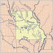
 Major Missouri rivers | |
| Location | |
| Country | US |
| State | Iowa, Missouri[1] |
| Physical characteristics | |
| Source | |
| • location | Creston, Iowa, US |
| • coordinates | 41°01′30″N 94°16′05″W / 41.025°N 94.268°W |
| Mouth | Missouri River |
• location | Brunswick, Missouri, US |
• coordinates | 39°23′02″N 93°06′29″W / 39.384°N 93.108°W |
• elevation | 620 ft (190 m) |
| Discharge | |
| • location | Sumner, MO |
| • average | 4,288 cu/ft. per sec.[2] |
The Grand River is a river that stretches from northernmost tributary origins between Creston and Winterset in Iowa approximately 226 miles (364 km)[3] to its mouth on the Missouri River near Brunswick, Missouri.
Its watershed of 7,900 square miles (20,000 km2), with three-quarters in Missouri, makes it the largest watershed serving the Missouri River in northern Missouri.[4]
- ^ U.S. Geological Survey Geographic Names Information System: Grand River (Missouri)
- ^ "USGS Surface Water data for Missouri: USGS Surface-Water Annual Statistics".
- ^ U.S. Geological Survey. National Hydrography Dataset high-resolution flowline data. The National Map Archived 2012-03-29 at the Wayback Machine, accessed May 26, 2011
- ^ "Missouri Department of Conservation Grand River Watershed Inventory Assessment". Archived from the original on 2008-06-15. Retrieved 2007-02-05.
© MMXXIII Rich X Search. We shall prevail. All rights reserved. Rich X Search
