Back مقاطعة غرانت (أوريغون) Arabic Grant County, Oregon BAR Грант (окръг, Орегон) Bulgarian গ্রান্ট কাউন্টি, অরেগন BPY Grant Gông (Oregon) CDO Грант (гуо, Орегон) CE Grant County (kondado sa Tinipong Bansa, Oregon) CEB Grant County, Oregon Welsh Grant County (Oregon) German Condado de Grant (Oregón) Spanish
This article needs additional citations for verification. (October 2007) |
Grant County | |
|---|---|
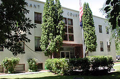
 Grant County Courthouse in Canyon City | |
 Location within the U.S. state of Oregon | |
 Oregon's location within the U.S. | |
| Coordinates: 44°26′18″N 118°53′30″W / 44.43841°N 118.89173°W | |
| Country | |
| State | |
| Founded | October 14, 1864 |
| Named for | Ulysses S. Grant |
| Seat | Canyon City |
| Largest city | John Day |
| Area | |
| • Total | 4,529 sq mi (11,730 km2) |
| • Land | 4,529 sq mi (11,730 km2) |
| • Water | 0.7 sq mi (2 km2) 0.02% |
| Population (2020) | |
| • Total | 7,233 |
| • Estimate (2023) | 7,215 |
| • Density | 1.6/sq mi (0.6/km2) |
| Time zone | UTC−8 (Pacific) |
| • Summer (DST) | UTC−7 (PDT) |
| Congressional district | 2nd |
| Website | www |
Grant County is one of the 36 counties in the U.S. state of Oregon. As of the 2020 census, the population was 7,233,[1] making it Oregon's fourth-least populous county. The county seat is Canyon City.[2] It is named for President Ulysses S. Grant,[3] who served as an army officer in the Oregon Territory, and at the time of the county's creation was a Union general in the American Civil War.
Grant County is included in the 8 county definition of Eastern Oregon.
- ^ "State & County QuickFacts". United States Census Bureau. Retrieved May 20, 2023.
- ^ "Find a County". National Association of Counties. Archived from the original on May 31, 2011. Retrieved June 7, 2011.
- ^ Gannett, Henry (1905). The Origin of Certain Place Names in the United States. Govt. Print. Off. pp. 141.
© MMXXIII Rich X Search. We shall prevail. All rights reserved. Rich X Search