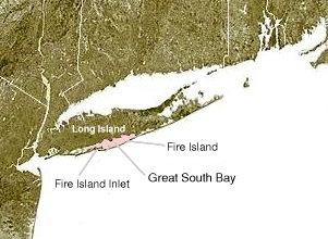
The Great South Bay of the United States is a lagoon[1] situated between Long Island and Fire Island, in the State of New York. It is about 45 miles (72 km) long and has an average depth of 4 feet 3 inches (1.3 m) and is 20 feet (6.1 m) at its deepest.[2] It is protected from the Atlantic Ocean by Fire Island, a barrier island, as well as the eastern end of Jones Beach Island and Captree Island.
The Robert Moses Causeway adjoins the Great South Bay Bridge, which leads to Robert Moses State Park.

The bay is accessible from the ocean through Fire Island Inlet, which lies between the western tip of Fire Island and the eastern tip of Jones Beach Island. The bay adjoins South Oyster Bay on its western end, and Patchogue and Moriches bays at the east end.
- ^ Goodbred Jr., S.; Locicero, P.; Bonvento, V.; Kolbe, S.; Holsinger, S. "History of the Great South Bay estuary: Evidence for a catastrophic origin" (PDF). State University of New York (SUNY.com). Retrieved 2013-10-02.
- ^ "Loving L9ng Island: The Great South Bay Long Island, New York". Retrieved 2020-08-02.
© MMXXIII Rich X Search. We shall prevail. All rights reserved. Rich X Search
