Back बिशाल नेपाल Bihari Velký Nepál Czech Μεγάλο Νεπάλ Greek Gran Nepal Spanish विशाल नेपाल Hindi Greater Nepal HIF Nepal Raya ID विशाल नेपाल Nepali عظیم نیپال PNB عظیم نیپال Urdu


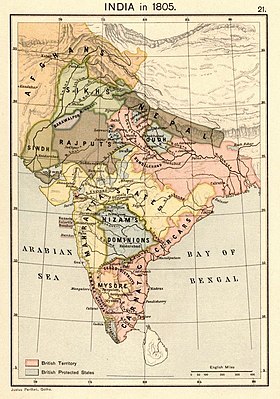
Greater Nepal refers to the concept of a unified Nepal encompassing the territories within its borders during the period between 1791 and 1816.[1][2] Extensive territories in the present-day Indian states of Uttar Pradesh, Bihar, West Bengal and some parts of Bangladesh were conquered during the unification campaign of Nepal led by King Prithvi Narayan Shah.[3][4] The campaign ended with the Anglo-Nepalese War and the signing of the Sugauli Treatry between the Kingdom of Nepal and East India Company on March 4, 1816.[5]
- ^ Verma, Jai Kumar (19 September 2020), "Greater Nepal: A spark which could become a fire", Aviation and defence,
The growing concept of "Greater Nepal" is an irredentist notion which visualises to include several areas of India which were occupied by Gorkha army after conquering the neighbouring states between 1791 to 1804.
- ^ Amy Johnson, Don’t Break the State: Indivisibility and Populist Majority Politics in Nepal, Society for Cultural Anthropology, 16 March 2021.
- ^ Mulmi, Amish Raj. "The Making of the Gorkha Empire: Part I – Land". The Record. Retrieved 21 December 2021.
- ^ Cite error: The named reference
Mishra & Haquewas invoked but never defined (see the help page). - ^ Cite error: The named reference
TOI 2005was invoked but never defined (see the help page).
© MMXXIII Rich X Search. We shall prevail. All rights reserved. Rich X Search