Back Guadalcanal Province CEB Guadalcanal (Provinz) German Provincia de Guadalcanal Spanish استان گودال کانال Persian Province de Guadalcanal French Guadalcanal (Prowins) FRR Provincia de Guadalcanal Galician Guadalcanal (provincija) Croatian Provinsi Guadalkanal ID Provincia di Guadalcanal Italian
_type:adm1st_source:GNS-enwiki 9°45′S 160°00′E / 9.750°S 160.000°E
Guadalcanal Province
Guadalkanal Provins (Pijin) | |
|---|---|
 | |
| Coordinates: 9°45′S 160°0′E / 9.750°S 160.000°E | |
| Country | |
| Capital | Honiara |
| Government | |
| • Premier | Francis Belande Sade |
| Area | |
| • Total | 5,336 km2 (2,060 sq mi) |
| Population (2021 census) | |
| • Total | 161,197 |
| • Density | 11.3/km2 (29/sq mi) |
| Time zone | UTC+11 (+11) |
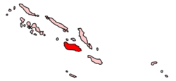
Guadalcanal Province is one of the nine provinces of Solomon Islands, consisting of the island of Guadalcanal. It is a 2,510 square mile (5,336 km2) island and is largely a jungle. Its name was given by Pedro de Ortega Valencia, born in the village of Guadalcanal, Seville, Spain. The national capital and largest city of the Solomon Islands, Honiara, is on the island; in July 1983, it was designated a 22 km2 (8.5 sq mi) separately-administered Capital Territory and is no longer considered part of the province. The population of the province is 93,613 (2009), not including the capital territory. The population of the island (including Honiara) is 161,197 (as of 2021). Honiara serves as the provincial capital.[1][2] The climate is rainforest tropical.[3] The estimated terrain elevation above sea level is 447 meters (1,467 ft).[4]
- ^ "About Guadalcanal Solomon Islands | Solomon Airlines". www.flysolomons.com. Solomon Airlines. Retrieved 13 June 2019.
- ^ "Office of the Auditor General - Guadalcanal Province". www.oag.gov.sb. Retrieved 13 June 2019.
- ^ "Climate Guadalcanal Province: Temperature, climate graph, Climate table for Guadalcanal Province - Climate-Data.org". en.climate-data.org. Retrieved 13 June 2019.
- ^ "Guadalcanal Province first-order administrative division, Guadalcanal, Solomon Islands". sb.geoview.info. Retrieved 13 June 2019.
© MMXXIII Rich X Search. We shall prevail. All rights reserved. Rich X Search
