Back نهر جودجينبى ARZ Gudgenby River CEB Gudgenby River German Kogin Gudgenby Hausa Gudgenby River Swedish
| Gudgenby | |
|---|---|
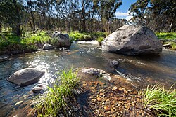
 A bend in the Gudgenby River near the Glendale Picnic area in the Namadgi National Park | |
| Location | |
| Country | Australia |
| Territory | Australian Capital Territory |
| Region | South Eastern Highlands (IBRA), Capital Country |
| Physical characteristics | |
| Source | Mount Gudgenby and Yankee Hat, Brindabella Range |
| Source confluence | Bogong Creek and Middle Creek (Australian Capital Territory) |
| • location | Namadgi National Park |
| • coordinates | 35°46′17″S 148°56′31″E / 35.77139°S 148.94194°E |
| • elevation | 995 m (3,264 ft) |
| Mouth | confluence with the Murrumbidgee River |
• location | near Tharwa |
• coordinates | 35°31′14″S 149°4′33″E / 35.52056°S 149.07583°E |
• elevation | 573 m (1,880 ft) |
| Length | 35 km (22 mi) |
| Basin features | |
| River system | Murrumbidgee River, Murray–Darling basin |
| Tributaries | |
| • left | Nursery Creek, Orroral River, Booroomba Creek, Naas River |
| • right | Hospital Creek (ACT), Dry Creek (ACT), Half Moon Creek |
| [1] | |
The Gudgenby River, a perennial river that is part of the Murrumbidgee catchment within the Murray–Darling basin, is located in the Australian Capital Territory, Australia.
- ^ "Map of Gudgenby Creek, ACT". Bonzle.com. Retrieved 14 February 2013.
© MMXXIII Rich X Search. We shall prevail. All rights reserved. Rich X Search
