Back Desert i Semidesert del Golf d'Oman Catalan Έρημος και ημιέρημος του Κόλπου του Ομάν Greek Desierto y semidesierto del golfo de Omán Spanish بیابان و نیمهبیابان دریای عمان Persian Deserto e semideserto del golfo di Oman Italian Omanbukta ørken og halvørken NN Пустелі та напівпустелі Оманської затоки Ukrainian
| Gulf of Oman desert and semi-desert | |
|---|---|
 | |
 Map of the ecoregion | |
| Ecology | |
| Realm | Afrotropical |
| Biome | deserts and xeric shrublands |
| Borders | |
| Geography | |
| Area | 62,420 km2 (24,100 sq mi) |
| Countries | |
| Conservation | |
| Conservation status | Critical/endangered[1] |
| Protected | 1.58%[2] |
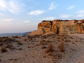
The Gulf of Oman desert and semi-desert is a coastal ecoregion on the Persian Gulf and the Gulf of Oman in Oman and the United Arab Emirates at the northeastern tip of the Arabian Peninsula. The climate is hot and dry, with gravelly plains and savanna with thorny acacia trees inland from the coast. Along the coast there are mixture of habitats that include mangrove swamps, lagoons and mudflats. The mangrove areas are dominated by Avicennia marina and the savanna by Prosopis cineraria and Vachellia tortilis. Masirah Island is an important breeding area for the loggerhead sea turtle and other sea turtles also occur here, as well as a great variety of birds, some resident and some migratory. There are some protected areas, but in general the habitats have been degraded by the grazing of livestock, especially camels and goats; they are also at risk from oil spills, off-road driving and poaching.[3]
- ^ "Gulf of Oman desert and semidesert". Terrestrial Ecoregions. World Wildlife Fund.
- ^ "Gulf of Oman desert and semi-desert". DOPA Explorer. Accessed 18 April 2021. [1]
- ^ "Gulf of Oman desert and semi-desert". Encyclopedia of the Earth. Retrieved November 12, 2020.
© MMXXIII Rich X Search. We shall prevail. All rights reserved. Rich X Search